Holme’s map covered over 200,000 acres, from New Castle to the falls of the Delaware, about 55 miles across and 33 miles north from the river. 1. He plotted rivers like the Delaware and the Schuylkill, streams like the Neshaminy and the Poquessing, and marshes along the rivers. He showed the counties of New Castle, Bucks, Chester and Philadelphia, the outline of the city of Philadelphia and a few towns like Calcoon Hook. Of the twenty-one named rivers and creeks, one was an error, almost certainly by the engraver. “Filpot River” should be Shelpot Creek, a tributary of the Brandywine. Some of our waterways still keep the names on the map: the Delaware, the Schuylkill, the Brandywine, Frankford Creek, and Poquessing Creek among them.
Holme included the manors, large chunks of acreage that Penn reserved for his own family, to generate income through land rental and sales. 2 There were five in Penn’s name (Springettsberry, Rocklands, Highlands, Pennsberry, and Gilberts), one for his wife Gulielma (Springfield), and one each for his daughter Laetitia and son William (Mount Joy and Williamstadt). Other large tracts were granted to Penn’s relatives the Lowthers and to Nicholas More, president of the Society of Traders. 3
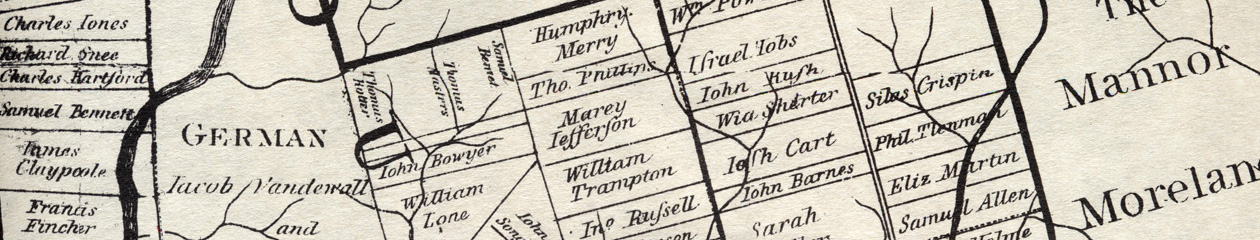
The special feature of Holme’s map is the names of landowners, each one placed on his or her land, about 780 names in all. This type of cadastral map, showing surveyed tracts of land, was unusual, almost unique for the early American colonies. 4 Many people owned more than one tract. There were about 620 unique personal names.
Holme omitted names of many who owned land at the time. Some tracts were not precisely known to him, like the land in the Northern Liberties, where he left out the settlers like Jurian Hartsfelder, Peter Cock, Swen Lom and others. He left out many of the Swedes who owned land along the two rivers before the English came, partly because he did not know exactly where their lands were, and partly because some of them lived in settlements like Chester and Marcus Hook, where the town lots were too small to show. The only place he expanded with an inset map was the city of Philadelphia itself.
Holme labelled several townships without any individual land holdings. He did not have the surveys for Haverford and Radnor, because his dishonest deputy Charles Ashcom had refused to give him exact returns of surveys. (Ashcom often surveyed larger tracts than he was supposed to, since he got paid as a proportion of the acreage.) Ashcom left for Maryland around 1686, and Holme simply left the Welsh townships blank.
Germantown was a special case. It had been settled in October 1683 by a group of thirteen families from Krefeld on the Rhine, and laid out like a European town with closely grouped lots strung along Germantown Road. The town lots were too small to be labeled with owners’ names, so once again Holme simply called the whole thing “German township Jacob Vandewall and company”. 5
It has been said that, “All maps are ideological statements about the world”. 6 Because most of the Welsh, Swedes, and Germans were omitted from the map, it has the effect of making the province seem more English. The tracts so neatly outlined and labeled make the land seem settled, tamed. The wilderness and its native inhabitants have been pushed back to the margins. The land has been advertised as safe for Englishmen, both settlers and investors.
- Klinefelter ↩
- Lemon, Best Poor Man’s Country ↩
- Technically the owner of a manor had feudal privileges like holding a court-baron, but no one in Pennsylvania used these in practice. See Soderlund, page 49. ↩
- The Manatus map of New Amsterdam was very early and showed names of some landowners, but it is quite different from Holme’s map in content and design. ↩
- For the unique nature of Germantown, see Urban Village by Stephanie Grauman Wolf. ↩
- John Overholt, curator of rare books and manuscripts at Harvard, “Harvard finds 1769 New Jersey Map…”, New York Times, January 2, 2016. ↩