In 1682 William Penn was in the business of selling land. He had a lot to sell, having received the province of Pennsylvania as a grant from King George the year before. Penn needed to raise money to cover his debts, and he wanted settlers for the land, especially Quakers, who were battered by persecution in England. Hauled into court, thrown into prison, and pestered by fines and seizure of their goods and crops, many were eager to leave for the freedom of Penn’s province.
Others were intrigued by Pennsylvania land as an investment. Wealthy merchants, some Quakers and some not, did not plan to emigrate themselves, but wanted land to place settlers on or as a base for commerce. A few had dreams of commercial empires based on fur trading and whaling.
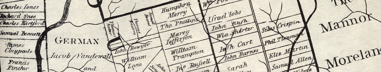
The buyers, whatever their motivation, wanted to see what they were getting. Penn needed something to show them, and after a few years’ delay he finally got what he needed—a map. His surveyor general, Thomas Holme, drafted it and sent it to England to be printed. Penn and his business agents were pleased, and future historians were delighted, for this map was unique and wonderful. It showed the geography of the province, with its rivers, the mighty Delaware and flowing Schuylkill, and many streams. But it also laid out the land owners. By 1685 much of the lower counties, Chester, Philadelphia, and Bucks, had been bought from the Indians and sold to the settlers. The map showed their holdings, in tidy blocks, each one labelled with a name.
Who are the names on the map? With some digging through records it is possible to pin down their identity, find whether they were Quaker or not, see whether they emigrated and what they did for a living. This paints a rich and fine-grained portrait of the early landowners. But there is something missing — the people who are not on the map. Holme lumped the Germans together into the German township without naming them, did the same with the Welsh in Radnor and Haverford, and did the same with the Swedes along the Delaware River. This had the effect of making the province seem more homogeneous and English, whether Holme intended this or not. More seriously, the map largely omits the women, the servants, the slaves, and the native peoples. They are the faces hiding behind the white male landowners.
This study will look at everyone: the landowners, the unnamed Germans and Swedes and Welsh, the women, the slaves and indentured servants, the native Lenni Lenape. It will use data to tell a collective story, and individual stories to bring characters to life, like Elizabeth Shorter, cheated by her son-in-law, or Philip Theodore Lehnmann, Penn’s hapless private secretary, who almost caused him to lose the city of Philadelphia in the boundary dispute with Lord Baltimore.