Category Archives: Holme’s map

Laying out the countryside

William Penn had definite ideas for how Philadelphia should look. He also knew how his countryside should look. Instead of scattered farms on widely separated plots, he wanted the people grouped together into communities, for “Society, assistance, Busy Commerce, Instruction of Youth, Government of Peoples manners, Conveniency of Religious Assembing, Encouragement of Mechanicks, distinct and beaten roads”. 1

Penn specified one way to accomplish this.  “We have another Method … “Five hundred acres are allotted for the Village, which among ten families, comes to fifty acres each. This lies square, and on the outside of the Square stand the houses, with their fifty acres running back, where ends meeting make the Centre of the 500 acres as they are to the whole. Before the doors of the Houses lies the High way, and cross it, every man’s 450 acres of Land that makes up his complement of 500, so that the Conveniency of neighborhood is made agreeable with that of the Land.” 2

This is not very clear, but the idea might be something like the layout of Newtown township in Bucks County.

Newtown in sepia

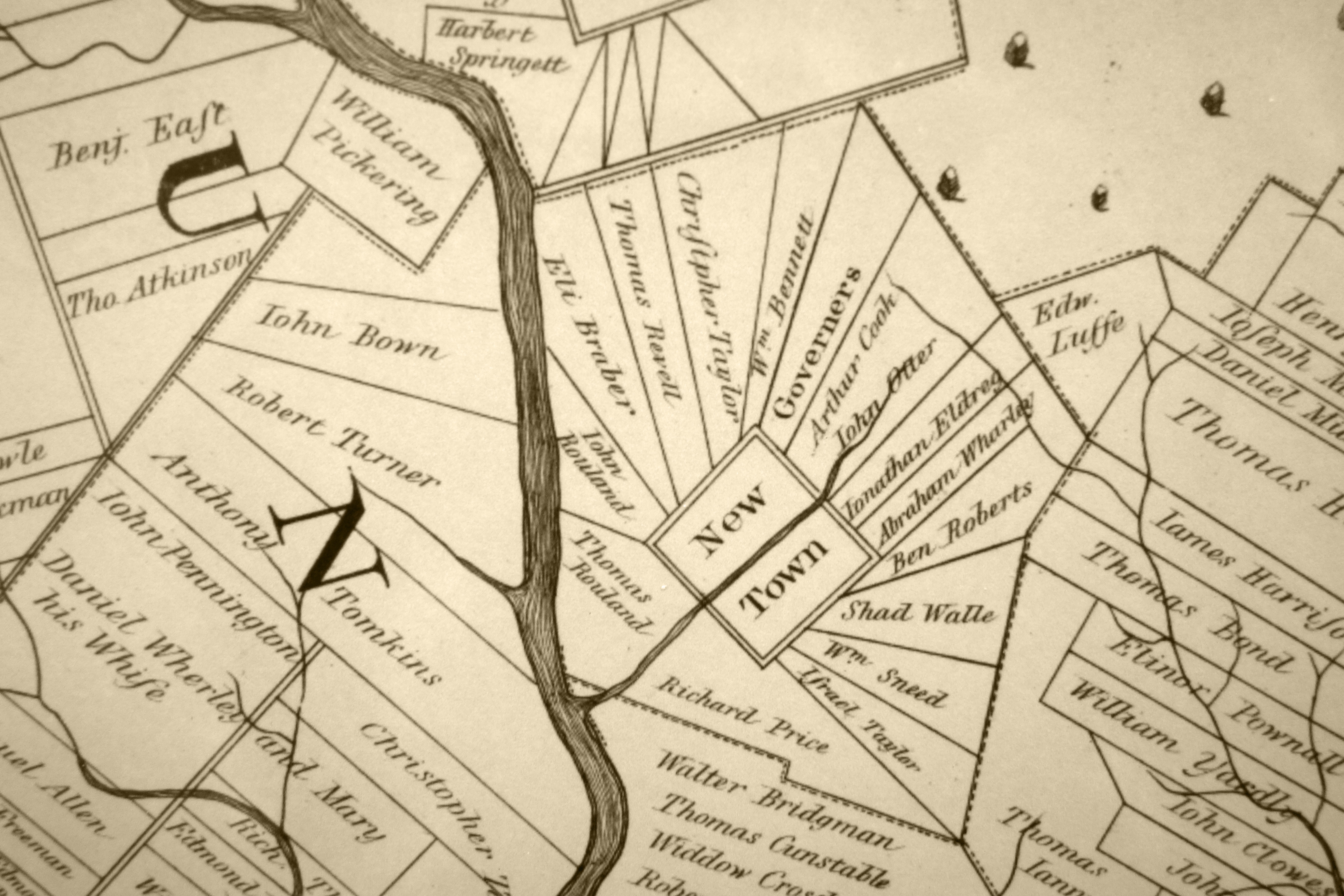
You see the plots radiating out from the center. You also see that the neat geometry that Penn imagined was interrupted by the natural geography, in this case Neshaminy Creek. Other factors could also interfere with the idea of neat rectangles. The townships along the Delaware River had tracts that were particularly long and skinny, to give more settlers access to the valuable river frontage. Germantown grew up as a linear village, strung out along an existing road. 3 Some land in Chester and Philadelphia Counties had to accommodate existing rights of the Swedes, whose lands were sometimes irregular in shape.

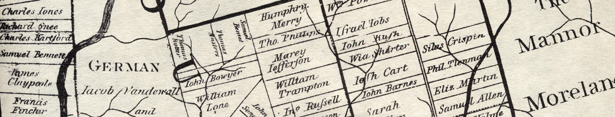
The three counties — Philadelphia, Chester and Bucks– were laid out early, although their precise boundaries were not specified at first. Some of the townships were laid out and named early as well, especially those in the southern part of each county, where settlement was densest. Penn wanted a one-tenth share in each township reserved for him, but Holme admitted to Penn that he had neglected this under pressure from settlers who wanted the land.

The other requirement for Penn was for contiguous settlement, with no gaps between tracts as the land was laid out. His surveyors were to start with existing lots like the ones along the rivers and to proceed inland in an orderly way. For the most part, settlement proceeded as he wished, with one notorious exception that almost cost Holme his job. In 1686 Charles Pickering, a Philadelphia merchant who had been convicted of counterfeiting in 1683, learned from an Indian of mineral deposits in northern Chester County. The word got around, and John Gray, a colorful character who may have been a lapsed Benedictine monk, tried to get a survey for the deposits. He persuaded Thomas Fairman, one of Holme’s assistants who looked out for his own interests, to lay out the survey, far beyond any existing surveyed land. Holme found out and determined to follow Penn’s instructions. He ran a series of surveys in a chain, leading north from existing tracts and ending up in Pickering’s site. When Penn found out, he was furious at the irregular survey, partly because he wanted land with lucrative mineral deposits reserved for him. He wrote to the commissioners that “Thomas deserves … to loose his office if I am rightly informed.” 4 Holme wrote to Penn (who was back in England at this time) and placated him. In any case, after all the furor, the mine came to nothing.

  1.  Albert Cook Myers, Narratives of Early Pennsylvania West New Jersey and Delaware, “A Further Account of Pennsylvania”, p. 263.
  2. Myers, p. 263
  3. S. G. Wolf, Urban Village
  4. Minutes of the Board of Property, Book C, in Penna. Archives, series 2, volume XIX, p. 7.

The green country town that never was

In 1681 William Penn was “extraordinarily busy” on behalf of his new colony, but he was not yet ready to leave England. He needed someone to deal with the land in his place, so he appointed commissioners. They had to select a site for the town, negotiate with the Indians and buy the land, begin to sell and lay out land to the purchasers. It was a big responsibility and he chose men he trusted, seasoned older men with experience—his cousin William Crispin, Nathaniel Allen, John Bezer, and William Haige. They prepared to sail to Pennsylvania and assume their new job. 1

“His Philadelphia was to be a city such as the world had never seen (and never would see).” 2

Penn had a vision for his town. It would be as unlike London as possible. A line of country houses, each one on its spacious plot, surrounded by orchards and fields, set well back from river — this was his idea, “a green country town which will never be burnt and always be wholesome.” Any Londoner Penn’s age would remember the plague of 1665 and the Great Fire of 1666. His spacious green city would not suffer such a fate. 3

Great_Fire_London

He had promised the First Purchasers that they would get a bonus lot in the city, one acre for every fifty acres purchased. To keep his promise if all 500,000 acres were sold, he would need 10,000 acres. He sent the commissioners with detailed instructions for picking out a suitable tract. It was to be in a place where the Delaware was navigable, and the bank “high, dry and healthy”. Marshy places would breed disease and offer poor moorage for ships. Ships should be able to load and unload at the river bank, and there should be a creek for smaller boats to unload. Preferably it would be open land, not taken up and settled already, but if the most convenient place was already taken up, the commissioners were to persuade the owners to trade some waterside land for land further back. This was the charge Penn gave the commissioners as he sent them on their way in the fall of 1681. 4

As it turned out, being one of Penn’s commissioners was not a healthy thing. William Crispin never reached Pennsylvania and died on the way. To replace him, Penn turned to Thomas Holme, an Englishman who had fought in Cromwell’s army when it subdued Ireland. Holme stayed on after the campaign ended in 1653 and became a Quaker. As a soldier he worked as an engineer and a surveyor. As a Quaker he spent time in Dublin prison with Quaker merchants like Samuel Claridge and Robert Turner. Penn made Holme his Surveyor General, with broad responsibility. Holme sailed in the summer of 1682 on the Amity with his children and servants, ready to join the other three commissioners and to lay out the province. 5

When the commissioners arrived and looked for sites for the town, they did not find virgin land on the river. The land on the Delaware had been settled for almost fifty years by a mix of Swedes and Finns, part of a little colony sent out from Sweden in the 1630s. There were only a few hundred of them when the Quakers arrived, but their lands were spread out along the Delaware and Schuylkill Rivers, leaving no large tract unsettled between New Castle and the falls of the Delaware near later-day Trenton. To get a large tract on the Delaware the commissioners would have to bargain with landowners. Looking for the best option, the commissioners chose a site owned by Swan Swanson and his sons, on the Delaware north of Upland. It was well provided with small streams, heavily wooded and had a high bank. In addition it had a cove where small boats could be moored. To buy out the Swansons the commissioners offered twice as much land up the Schuylkill. This would give Penn 300 acres for his city, with a fine high bank along the Delaware. Another purchase, from Peter Cock and Peter Rambo, extended the tract to 1200 acres. Why didn’t the commissioners buy more land? The answer was probably in Penn’s instructions to them, where he urged them to “Be as sparing as ever you can.” Penn did not want to spend more than he needed to, and buying 10,000 acres on the Delaware would have meant buying out many more owners. 6

Because the tract was smaller than the 10,000 that Penn originally planned, he could not give the First Purchasers the bonus lots he had promised them.  The solution to this problem was to give the bonus land in two pieces — a city lot and a larger tract north and west of the city, in what is now the Northern Liberties. There is no record of what the First Purchasers thought of this compromise, but their actions spoke for them. Many of them sold their rights in the Liberties to others, keeping the valuable city lots instead.

With the site chosen and the promise of bonus land kept,  the plan of the city was set, and the way was clear for people to claim their lots, build houses and wharves and warehouses, and begin the process of making Penn’s green town into a bustling center of trade and commerce.

  1. Jean Soderlund, William Penn and the Founding of Pennsylvania, p. 82.
  2. Richard Ryerson, “William Penn’s Commissioners”, PA Genealogical Magazine, 1981-82, vol. 32.
  3. Soderlund, p. 85. The image is from the Wikipedia entry for the Great Fire. The painting is by an unknown artist.
  4. Soderlund, pp. 83-85.
  5. Silvio Bedini, Thomas Holme (1624-1695) Pennsylvania’s First Surveyor-General
  6. Hannah Benner Roach, “The Planting of Philadelphia part 1”, PA Magazine of History & Biography, 1968, volume 92, pp. 13-15, 23. Soderlund, p. 204.

How it all started

In 1682 William Penn was in the business of selling land. He had a lot to sell, having received the province of Pennsylvania as a grant from King George the year before. Penn needed to raise money to cover his debts, and he wanted settlers for the land, especially Quakers, who were battered by persecution in England. Hauled into court, thrown into prison, and pestered by fines and seizure of their goods and crops, many were eager to leave for the freedom of Penn’s province.

Others were intrigued by Pennsylvania land as an investment. Wealthy merchants, some Quakers and some not, did not plan to emigrate themselves, but wanted land to place settlers on or as a base for commerce. A few had dreams of commercial empires based on fur trading and whaling.

The buyers, whatever their motivation, wanted to see what they were getting. Penn needed something to show them, and after a few years’ delay he finally got what he needed—a map. His surveyor general, Thomas Holme, drafted it and sent it to England to be printed. Penn and his business agents were pleased, and future historians were delighted, for this map was unique and wonderful. It showed the geography of the province, with its rivers, the mighty Delaware and flowing Schuylkill, and many streams. But it also laid out the land owners. By 1685 much of the lower counties, Chester, Philadelphia, and Bucks, had been bought from the Indians and sold to the settlers. The map showed their holdings, in tidy blocks, each one labelled with a name.

Who are the names on the map? With some digging through records it is possible to pin down their identity, find whether they were Quaker or not, see whether they emigrated and what they did for a living. This paints a rich and fine-grained portrait of the early landowners. But there is something missing — the people who are not on the map. Holme lumped the Germans together into the German township without naming them, did the same with the Welsh in Radnor and Haverford, and did the same with the Swedes along the Delaware River. This had the effect of making the province seem more homogeneous and English, whether Holme intended this or not. More seriously, the map largely omits the women, the servants, the slaves, and the native peoples. They are the faces hiding behind the white male landowners.

This study will look at everyone: the landowners, the unnamed Germans and Swedes and Welsh, the women, the slaves and indentured servants, the native Lenni Lenape. It will use data to tell a collective story, and individual stories to bring characters to life, like Elizabeth Shorter, cheated by her son-in-law, or Philip Theodore Lehnmann, Penn’s hapless private secretary, who almost caused him to lose the city of Philadelphia in the boundary dispute with Lord Baltimore.