Holme’s map of the countryside

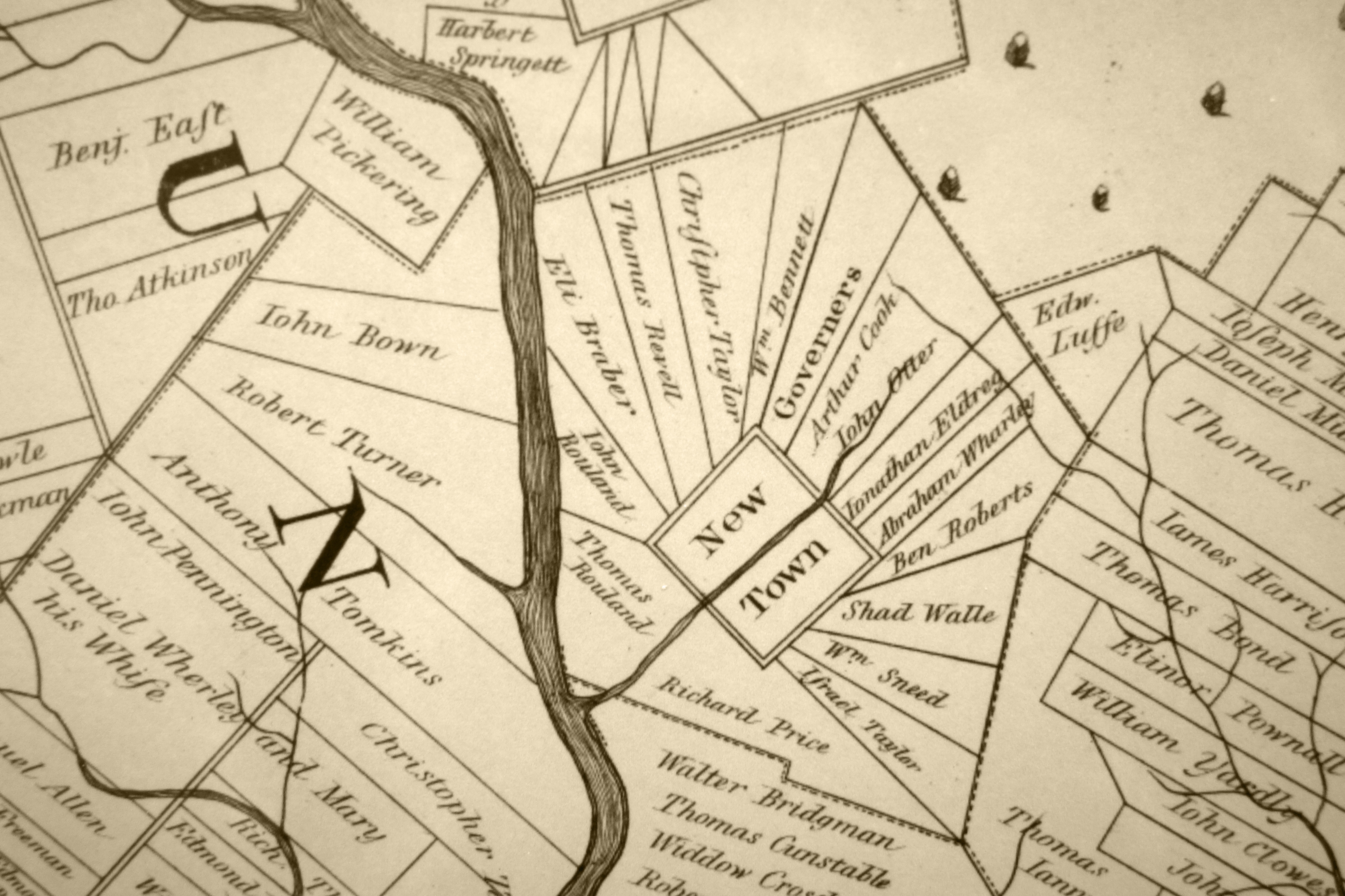
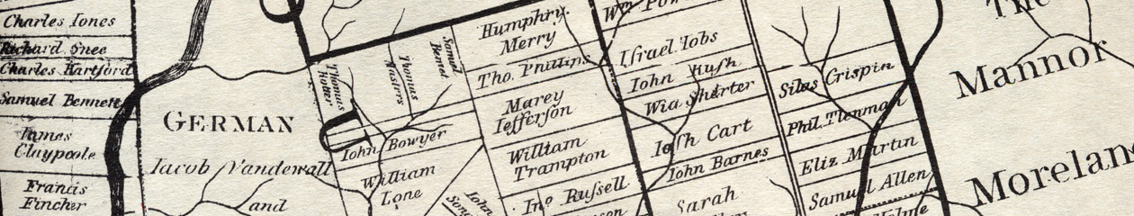
While Thomas Holme was busy serving in Penn’s government and supervising surveys, he was also working on his map of the countryside, the work for which he is still remembered today. This was more ambitious than his map of the city, covering over 200,000 acres. It was a magnificant achievement – at once a marketing tool, a piece of propaganda, a geographical representation, and a record of land ownership. It has been reprinted in countless state, county and township histories. It purports to show the ownership of most of the land in the three counties, and if accurate, serves as the starting point for the chain of ownership to the present day.

It is not fully clear why Penn wanted the map. It could have been a marketing tool to show prospective buyers, except that much of the land was already sold and settled by 1687, as the map itself showed. Perhaps he wanted it to show absentee owners where their land was situated. As we will see later, a substantial number of the owners on the map did not emigrate, and never saw their land in person. The map also served to promote the colony to potential investors, those merchants who might provide capital for business and trade.

To make the map, Holme got information from his deputy surveyors, although not as much or as quickly as he wanted. Charles Ashcom and Israel Taylor were slow to provide maps or lists of surveys, because Holme was entitled to a third of the fees they earned for each survey, and by documenting their work they would have to pay up.

There were few accurate maps of the Delaware valley at this time (which was one cause of the boundary dispute between Penn and Lord Baltimore). The best available was a map of Maryland made by Augustine Hermann for Lord Baltimore in 1660. It showed good detail, although Hermann complained of his engraver “defiling the prints with many errors.” 1

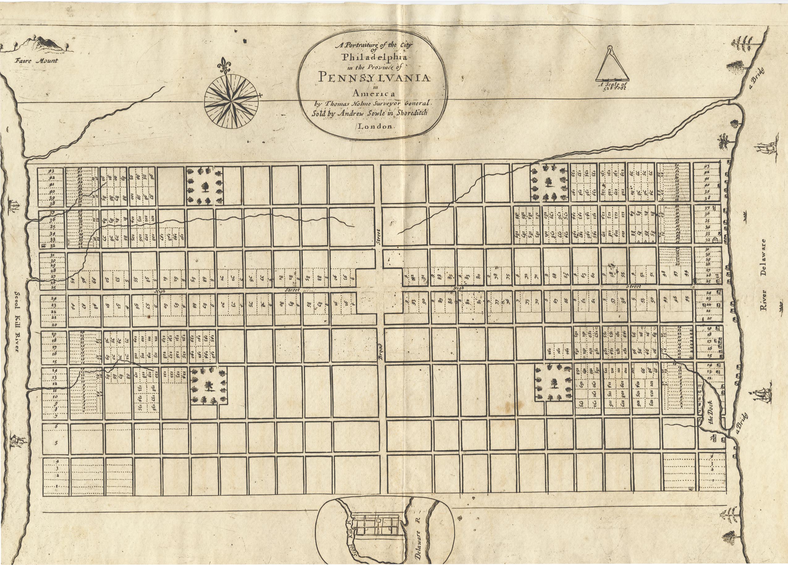
When he had enough information Holme drew the map, possibly on sheepskin, and sent it to England to be engraved, as there was no one in Pennsylvania at the time with the skill. 2 A letter of Holme’s in October 1686 referred to his intention to send it soon, and by May 1688 it was advertised for sale in the London Gazette. 3. The last survey included on the map was done for Jacob Pellison in February of 1686/87. 4

It was engraved by F. Lamb and published by Robert Green and John Thornton. The maps were five feet wide, came on seven sheets of paper, and cost 10 shillings. They were offered for sale in London, and it is possible that no copies were sold in Pennsylvania at all. 5 There is no record that Holme ever saw a printed copy of his map.

  1. Edward Mathews, Maps and mapmakers of Maryland, 1898.
  2. It is claimed that Holme drew his map of Philadelphia on sheepskin, so he probably did the other map that way as well. Silvio Bedini, Thomas Holme (1624-1695) Pennsylvania’s First Surveyor General.
  3. John Jordan, Colonial and Revolutionary Families of Pennsylvania, p. 340. Jordan believed that the map was published in a series of editions, of which the earlier ones are missing. This is erroneous, according to Klinefelter.
  4. At the time the year started in March, so Holme would have called this 1686, but in modern dates it is 1687. Since Quakers used numbers for the months, instead of pagan names, Holme actually would have called it 12th month 1686.
  5. Walter Klinefelter, Surveyor General Thomas Holme’s “Map of the Improved Part of the Province of Pennsilvania”, in Doud & Quimby, Winterthur Portfolio 6, 1970, pp. 41-74.

How people got their land

New arrivals in Pennsylvania could not just ride out into the countryside and claim a tract for their own. Penn set up an orderly process for laying out land purchases. Many of the emigrants had bought rights to land from him in England as First Purchasers. Others had bought up the rights from a First Purchaser. 1 Once they got off the boat, they went to Penn in Philadelphia and requested a survey, asking for all or part of their purchase to be laid out. Penn sent a warrant to Thomas Holme, asking him to have the land surveyed. Here is a typical warrant from Penn to Holme:

William Penn proprietary and Governor of the province of Pennsylvania and the territories thereunto belonging. At the request of Nicholas Rendal late purchaser one hundred and fifty acres that I would grant him to take up the said land in the county of Philadelphia. These are to will and require thee forthwith to survey or cause to be surveyed onto him the said number of acres in the aforementioned County where not already taken up according to the method of townships appointed by me, he seating  the same according to regulation and make returns thereof into my secretary’s office. Given at Philadelphia the 12th of the fourth month 1684.

For Thomas Holme Surveyor General.

[Holme added a note at the bottom.] 18th ordered T.F. [Thomas Fairman] to lay it out in Warminster Township if room there, to join to his father’s acres. 2

Holme might do the survey himself, or more often would delegate one of his assistants: typically Charles Ashcom for Chester County, Thomas Fairman for Philadelphia County, Israel Taylor for Bucks County. These men would direct the survey, which required a team of men — the surveyor and his chainmen. 3 The chainmen carried heavy chains, of known length, which they laid out according to directions from the surveyor. He used a compass, and possibly other tools such as a theodolite (for measuring angles), a protractor (for drawing angles), and a quadrant (for measuring altitude). 4 The survey was supposed to include an extra 6 percent allowance for roads that might be run through it at some time, although a shady surveyor might add extra land to please the purchaser and increase his fee. The fee was supposed to be shared, with one-third to the surveyor and two-thirds for Holme. 5 In practice the deputy surveyors tried to avoid sending Holme his fees, leading to several lawsuits. 6

Once the land was surveyed the purchaser could live on it, rent it out or sell it. If he did not settle on it in a reasonable amount of time, it could be forfeit to Penn, as in the warrant above, “….seating the same according to regulation.” In practice this was rare.

The final step in the purchase process was the patent. The owner could apply to the land office for a patent giving him full title to the land. After paying a fee he would receive a paper describing the property and documenting his right to it. Because there was a fee for this, owners often didn’t get a patent, and sold the land without one. But a cautious buyer would insist on it, and often a patent was dated just before the sale of the land.

  1. They could also buy land from Penn once they arrived.
  2. Warrant #2071. Warrant and Survey Book 1, Philadelphia City Archives
  3. In later years the team also included axmen, who cleared trees and brush along the boundaries of the tract. In the early years when Holme had fewer helpers, the chainmen probably doubled as axmen.
  4. Corcoran, Thomas Holme, p. 35
  5. Munger, Guide to Pennsylvania Land Records.
  6. Holme sued Taylor in 10th month 1686 (Court records of Bucks County) and Ashcom in 7th month 1690 (Court records of Chester County).

John Tatham, alias Gray: the secret Catholic

A Catholic in a land of Quakers, a man with a suspicious past, a target of dark rumors, builder of a palatial house – John Tatham stands out as unusual. He bought land from Penn in London and emigrated in 1685. Penn knew that he was Catholic and distrusted him. Penn wrote to Thomas Lloyd in 1685, “… he is subtile and prying and lowly… be sure to pleas him in his land…”. 1 Tatham built a large house in Bensalem, traded as a merchant, and soon ran into trouble with his neighbor Joseph Growdon. Growdon was a wealthy landowner, who wanted to assemble a manor of 10,000 acres, although Penn was reluctant to let him have so much in one place. Tatham’s Bensalem land stuck into Growdon’s like a thorn, and they soon began to squabble over land sales and money owed. They were in Bucks County court in 1686, and Phineas Pemberton called it the “most railing revileing business” he had ever seen, adding that they only behaved to “befoole them selves”. 2. The suit continued for years.

By 1686 Tatham had moved to New Jersey where he built a grand house that some called a palace. 3 At this time Penn learned astonishing news about Tatham. He was a former Benedictine monk who had left his order!  Penn’s suspicions about Tatham grew after an irregular survey made to Charles Pickering and Tatham over a tract supposed to include a silver mine. Penn was furious over this and threatened to fire Thomas Holme for allowing the survey. 4

Tatham’s power and influence grew when he was appointed as agent for Daniel Cox, the wealthy investor and absentee governor of West Jersey. Tatham worked with James Budd, Cox’s surveyor, but when Budd died under suspicious circumstances in 1690 Tatham was suspected of poisoning him. John Budd, James’ brother, accused Tatham, and Tatham sued Budd for defamation. The courthouse was packed with a great press of people, so that some witnesses could not be heard. The testimony was sensational. Jonathan West said that “James Budd after hee was dead swelled and looked black, and wrought in his belly and att his mouth, and that after hee was put into the coffin he swelled much.” William Budd, another brother, said that he met James walking in Burlington, who told him that he was under great trouble, with a letter in his pocket that meant his death. Nicholas Martineau added that Budd said his heart was “almost broke” because John Tatham would not pay him money necessary for his business. Elizabeth Bosse added darkly that Budd “dyed not the common death of all men”, but died of poison. The court must not have believed these tales, since it ruled for Tatham and awarded him damages. By then Tatham was on the council of Proprietors of West Jersey, had served as its president, and had also served on the Assembly. Although the Budd family was influential and well-off, he was more so. 5

The obvious question is how a former monk was able to build two grand houses, acquire merchandise to sell, and set himself up as one of the wealthiest men in either province.  The answer begins with his background from a well-to-do family in Yorkshire. He was sent to Douai University in France as a youth to study for the priesthood, and became a Benedictine. In 1676 he returned to England as Father Bede Tatham. In 1678 a supposed Popish plot to kill King Charles inflamed hysteria against Catholics. Perhaps at this time Tatham left his post and took the name John Gray. He must have married around 1680 since he had a daughter born around 1680 to 1682. 6 In 1684 he bought land from Penn and sailed to Pennsylvania, with his family, a large library and merchant goods. Perhaps the money came from his family, but he apparently also absconded with church money! Penn wrote in 1686 that “the congregation has spoak to the King about him, and to me.” The king commanded that Tatham be sent back to England by the first conveniency. 7  Obviously no one bothered to do that.

Tatham died in 1700, about 58 years old, leaving his pregnant wife Elizabeth, and three children. His will was dramatic. He left his daughter Dorothy “one piece of eight if demanded and no more”, for her “graceless and shameless rebellion”. 8 She had married a man named Robert Hickman, in custody of the sheriff in Burlington as a suspected pirate. They married clandestinely at Elizabeth Basnett’s tavern in February 1700, for which Basnett lost her tavern license. Tatham’s inventory included two crucifixes, gold church plate, seven slaves, a silver rapier, 478 books, and his grand house. He left everything to his wife Elizabeth, but she died soon after him. Their son John continued the suit against Growdon; it was still plaguing the court in 1713. 9

Bisbee asked whether Dorothy’s rebellion hastened his death. Whether  it did or not, the more interesting question is whether he rested easy in his conscience. If some of his wealth came from theft from his church, did that weigh on him?

  1. Henry Bisbee, “John Tatham, alias Gray”, PMHB, 1959, 83(3)
  2. Quoted in Lawmaking and Legislators, vol. 1, the entry on Joseph Growdon
  3. Gabriel Thomas, “An account of West Jersey and Pennsylvania”, quoted in Bisbee.
  4. Minutes of the Board of Property, series 2, 1687
  5. Burlington Court Records. Bisbee, p. 257
  6. Dorothy was of marriageable age in 1700.
  7. Quoted in Bisbee.
  8. A printed abstract in Publications of the Genealogical Society of PA, vol. 3, has “one piece of dirt”, but this is incorrect
  9. Martin Griffin, “Early Catholics of Bucks County”, Papers read before the Bucks County Historical Society. Also Minutes of the Board of Property, series 2.

Laying out the countryside

William Penn had definite ideas for how Philadelphia should look. He also knew how his countryside should look. Instead of scattered farms on widely separated plots, he wanted the people grouped together into communities, for “Society, assistance, Busy Commerce, Instruction of Youth, Government of Peoples manners, Conveniency of Religious Assembing, Encouragement of Mechanicks, distinct and beaten roads”. 1

Penn specified one way to accomplish this.  “We have another Method … “Five hundred acres are allotted for the Village, which among ten families, comes to fifty acres each. This lies square, and on the outside of the Square stand the houses, with their fifty acres running back, where ends meeting make the Centre of the 500 acres as they are to the whole. Before the doors of the Houses lies the High way, and cross it, every man’s 450 acres of Land that makes up his complement of 500, so that the Conveniency of neighborhood is made agreeable with that of the Land.” 2

This is not very clear, but the idea might be something like the layout of Newtown township in Bucks County.

Newtown in sepia

You see the plots radiating out from the center. You also see that the neat geometry that Penn imagined was interrupted by the natural geography, in this case Neshaminy Creek. Other factors could also interfere with the idea of neat rectangles. The townships along the Delaware River had tracts that were particularly long and skinny, to give more settlers access to the valuable river frontage. Germantown grew up as a linear village, strung out along an existing road. 3 Some land in Chester and Philadelphia Counties had to accommodate existing rights of the Swedes, whose lands were sometimes irregular in shape.

The three counties — Philadelphia, Chester and Bucks– were laid out early, although their precise boundaries were not specified at first. Some of the townships were laid out and named early as well, especially those in the southern part of each county, where settlement was densest. Penn wanted a one-tenth share in each township reserved for him, but Holme admitted to Penn that he had neglected this under pressure from settlers who wanted the land.

The other requirement for Penn was for contiguous settlement, with no gaps between tracts as the land was laid out. His surveyors were to start with existing lots like the ones along the rivers and to proceed inland in an orderly way. For the most part, settlement proceeded as he wished, with one notorious exception that almost cost Holme his job. In 1686 Charles Pickering, a Philadelphia merchant who had been convicted of counterfeiting in 1683, learned from an Indian of mineral deposits in northern Chester County. The word got around, and John Gray, a colorful character who may have been a lapsed Benedictine monk, tried to get a survey for the deposits. He persuaded Thomas Fairman, one of Holme’s assistants who looked out for his own interests, to lay out the survey, far beyond any existing surveyed land. Holme found out and determined to follow Penn’s instructions. He ran a series of surveys in a chain, leading north from existing tracts and ending up in Pickering’s site. When Penn found out, he was furious at the irregular survey, partly because he wanted land with lucrative mineral deposits reserved for him. He wrote to the commissioners that “Thomas deserves … to loose his office if I am rightly informed.” 4 Holme wrote to Penn (who was back in England at this time) and placated him. In any case, after all the furor, the mine came to nothing.

  1.  Albert Cook Myers, Narratives of Early Pennsylvania West New Jersey and Delaware, “A Further Account of Pennsylvania”, p. 263.
  2. Myers, p. 263
  3. S. G. Wolf, Urban Village
  4. Minutes of the Board of Property, Book C, in Penna. Archives, series 2, volume XIX, p. 7.

The grid of the city

When Thomas Holme arrived in the fall of 1682, the site for Philadelphia was already chosen. It was a fine location, 300 acres on the Delaware River, with abundant streams, a high bank, and a cove where small ships could land.

“Rising from either side of a natural, apparently centrally located watershed, many-branched steams flowed east and west into each river. At the southern end of the Delaware side, two of these streams emptied into the north and south extremities of the cove. Their water then coursed out into the Delaware through a narrow channel at the cove’s southern edge… Between the low sandy beach of the cove to the south… the Delaware’s banks rose gradually to a height of about thirty feet above the river, then shelved down abruptly to the Coaquannock.” 1

With the site chosen, the next step, and a tricky one, was to choose where different purchasers would have their land. At first the city lots were not for sale to “the general public”; they were a bonus for the First Purchasers, people who bought from Penn in England. There were 50 groups of First Purchasers, with each group paying for 10,000 acres. Each group was to receive a large city lot; if there were more than one buyer in a group, as there typically was, the lots would be subdivided. The plan was that the lots would be chosen and laid out by random drawing. The drawing was held on September 19, 1682. But before these lots could be laid out, word came that Penn was on his way from England and would arrive the next month. The layout could wait for his approval.

When he arrived, he found that many of the First Purchasers, including the majority of the largest ones, had not emigrated. This meant that, “Until these absentees came over, or sent agents or servants to develop their share of purchased land, eighty per cent of the town, as well as of the country land, would remain unimproved.” 2 This was undesirable from Penn’s standpoint; he wanted a thriving town as quickly as possible. The random drawing was probably not appealing to the purchasers as well, since they had no say in the location of their lots. So the plan was modified. Penn bought more land from the Swedes Peter Cock and Peter Rambo to open up a second river frontage on the Schuylkill. This expanded the city to 1200 acres and gave Penn a place to put purchasers who did not emigrate, “where their absence would be less noticeable.” 3

Thomas Holme’s next step was to lay out the grid of streets. The street facing the river Delaware was called Front Street, and this set the pattern for the other north-south streets — Second Street, Third Street, and so forth. The east-west streets were initially named for prominent men like the merchant James Claypoole, Thomas Holme and Thomas Wynne, a Welsh physician. These were soon renamed, as it was not in the Quaker spirit to honor individual men in this way. Today those are Walnut, Mulberry and Chestnut Streets.

Five open squares were cut into the grid, one in the center and one in each quadrant. The center square was to be for public buildings; in fact it still serves that purpose, as the site of City Hall. The other four squares were for public use. They were later named for Franklin, Washington, Rittenhouse and Logan, and still serve as parks today, although Logan Square turned into a circle when the Benjamin Franklin Parkway was laid out.

Now the lots could be laid out for purchasers. While he supervised this process, Holme also worked on drawing a map of the city, showing the rivers, the Dock, streets, and the five squares. Numbers on the map showed where lots were laid out. This map was called A Portraiture of the City of Philadelphia. It was published in 1683 as part of Penn’s letter to the Free Society, a group of investors, and was widely circulated. 4

Portraiture of the city of Philadelphia

The map was well-received in England. Philip Ford, one of Penn’s agents, wrote to Holme that, “As for the map of the city, it was needful it should be printed; it will do us a kindness, as we were at a loss for want of something to show the people.”

  1. Roach, “The Planting of Philadelphia, part 1, pp. 32-33
  2. Roach, p. 30.
  3. Roach, p. 30. Soderlund, William Penn and the Founding of Pennsylvania, p. 205.
  4. The map did not include the names of the lot-holders; there was an accompanying list. This should correspond to a list of First Purchasers, but there are many discrepancies.

The green country town that never was

In 1681 William Penn was “extraordinarily busy” on behalf of his new colony, but he was not yet ready to leave England. He needed someone to deal with the land in his place, so he appointed commissioners. They had to select a site for the town, negotiate with the Indians and buy the land, begin to sell and lay out land to the purchasers. It was a big responsibility and he chose men he trusted, seasoned older men with experience—his cousin William Crispin, Nathaniel Allen, John Bezer, and William Haige. They prepared to sail to Pennsylvania and assume their new job. 1

“His Philadelphia was to be a city such as the world had never seen (and never would see).” 2

Penn had a vision for his town. It would be as unlike London as possible. A line of country houses, each one on its spacious plot, surrounded by orchards and fields, set well back from river — this was his idea, “a green country town which will never be burnt and always be wholesome.” Any Londoner Penn’s age would remember the plague of 1665 and the Great Fire of 1666. His spacious green city would not suffer such a fate. 3

Great_Fire_London

He had promised the First Purchasers that they would get a bonus lot in the city, one acre for every fifty acres purchased. To keep his promise if all 500,000 acres were sold, he would need 10,000 acres. He sent the commissioners with detailed instructions for picking out a suitable tract. It was to be in a place where the Delaware was navigable, and the bank “high, dry and healthy”. Marshy places would breed disease and offer poor moorage for ships. Ships should be able to load and unload at the river bank, and there should be a creek for smaller boats to unload. Preferably it would be open land, not taken up and settled already, but if the most convenient place was already taken up, the commissioners were to persuade the owners to trade some waterside land for land further back. This was the charge Penn gave the commissioners as he sent them on their way in the fall of 1681. 4

As it turned out, being one of Penn’s commissioners was not a healthy thing. William Crispin never reached Pennsylvania and died on the way. To replace him, Penn turned to Thomas Holme, an Englishman who had fought in Cromwell’s army when it subdued Ireland. Holme stayed on after the campaign ended in 1653 and became a Quaker. As a soldier he worked as an engineer and a surveyor. As a Quaker he spent time in Dublin prison with Quaker merchants like Samuel Claridge and Robert Turner. Penn made Holme his Surveyor General, with broad responsibility. Holme sailed in the summer of 1682 on the Amity with his children and servants, ready to join the other three commissioners and to lay out the province. 5

When the commissioners arrived and looked for sites for the town, they did not find virgin land on the river. The land on the Delaware had been settled for almost fifty years by a mix of Swedes and Finns, part of a little colony sent out from Sweden in the 1630s. There were only a few hundred of them when the Quakers arrived, but their lands were spread out along the Delaware and Schuylkill Rivers, leaving no large tract unsettled between New Castle and the falls of the Delaware near later-day Trenton. To get a large tract on the Delaware the commissioners would have to bargain with landowners. Looking for the best option, the commissioners chose a site owned by Swan Swanson and his sons, on the Delaware north of Upland. It was well provided with small streams, heavily wooded and had a high bank. In addition it had a cove where small boats could be moored. To buy out the Swansons the commissioners offered twice as much land up the Schuylkill. This would give Penn 300 acres for his city, with a fine high bank along the Delaware. Another purchase, from Peter Cock and Peter Rambo, extended the tract to 1200 acres. Why didn’t the commissioners buy more land? The answer was probably in Penn’s instructions to them, where he urged them to “Be as sparing as ever you can.” Penn did not want to spend more than he needed to, and buying 10,000 acres on the Delaware would have meant buying out many more owners. 6

Because the tract was smaller than the 10,000 that Penn originally planned, he could not give the First Purchasers the bonus lots he had promised them.  The solution to this problem was to give the bonus land in two pieces — a city lot and a larger tract north and west of the city, in what is now the Northern Liberties. There is no record of what the First Purchasers thought of this compromise, but their actions spoke for them. Many of them sold their rights in the Liberties to others, keeping the valuable city lots instead.

With the site chosen and the promise of bonus land kept,  the plan of the city was set, and the way was clear for people to claim their lots, build houses and wharves and warehouses, and begin the process of making Penn’s green town into a bustling center of trade and commerce.

  1. Jean Soderlund, William Penn and the Founding of Pennsylvania, p. 82.
  2. Richard Ryerson, “William Penn’s Commissioners”, PA Genealogical Magazine, 1981-82, vol. 32.
  3. Soderlund, p. 85. The image is from the Wikipedia entry for the Great Fire. The painting is by an unknown artist.
  4. Soderlund, pp. 83-85.
  5. Silvio Bedini, Thomas Holme (1624-1695) Pennsylvania’s First Surveyor-General
  6. Hannah Benner Roach, “The Planting of Philadelphia part 1”, PA Magazine of History & Biography, 1968, volume 92, pp. 13-15, 23. Soderlund, p. 204.

The First Purchasers

People who bought land from Penn in England before 1685 are called First Purchasers. In July 1681 Penn signed a formal agreement promising them special privileges, the Conditions or Concessions.  For every 50 acres they were to receive a one-acre lot in the city. (This was later modified, as there was not enough land in the site chosen for the city. Instead they got a smaller city lot and a larger lot in the Liberties, an area just north of the city.) Penn wanted settlers, not land held vacant for speculation, so he stipulated that tracts over 1000 acres would not be laid out unless they were settled within three years. 1

The purchasers were buying rights to land, not a specific tract. When the deed was signed no one, neither Penn nor the buyer, knew where it would be located. This would be determined by the buyer on the spot after he emigrated (or sent an agent to represent him). Many of the First Purchasers did not emigrate and sold their rights to others, even years later in the 1700’s. The ones who appear on Thomas Holme’s map are those who exercised their rights by having their land surveyed. Of the 589 First Purchasers on the best available list, 234 of them appear on Holme’s map, fewer than half. 2

Most of the First Purchasers were Quakers. Penn’s network of agents were Quakers—men like James Harrison in Lancashire, Robert Turner in Dublin, Philip Ford in London. They publicized and marketed the colony as a Quaker settlement. A few non-Quaker relatives and friends of Penn like Herbert Springett, Sir William Petty, and Sir Henry Ingoldsby bought as a favor to Penn or as an investment. Large tracts were set aside for the Penn family including William’s children Letitia and William. 3

Most of them were English. “The First Purchasers were primarily Quaker merchants, craftsmen, shopkeepers, and farmers. Some of them came from Ireland, Wales. Scotland, Holland, France, Germany, the West Indies, and North America, but the great majority lived in the country districts of southern and western England, and in the cities of London and Bristol. About half of them actually migrated to Pennsylvania, bringing their families as well as many servants, and making possible the rapid development of the new colony.” 4

The First Purchasers bought tracts of land ranging from 125 acres to 10,000 acres, with the most common size as 500 acres. Five hundred acres was more than enough for a family farm, and any tract larger than that would almost certainly be settled by more than one family. Some of the largest tracts, in the northern edges, were sparsely settled if at all, contrary to Penn’s policy, but these were the exception.

The First Purchasers were vitally important to Penn and the settlement of Pennsylvania. They gave him an infusion of money that he needed, much of which he plowed into the province to support the government in its early years. And those who emigrated provided people to clear the land and begin the process of settlement.


  1. Soderlund, William Penn and the Founding of Pennsylvania, pp. 72-75
  2. The best available list was published by Richard Dunn and Mary Maples Dunn in the Papers of William Penn 1680-1684.  John Pomfret discussed the First Purchasers in 1956, summarized their origins and stated that about half of them emigrated, but he was working from less complete lists. John Pomfret, “The First Purchasers of Pennsylvania”, PMHB, 1956, volume 80.
  3. Pomfret, p. 149
  4. Soderlund, p. 75.

Selling the land

The charter from King Charles to William Penn in 1681 gave him ownership of the land with full rights to sell or rent it. The people who bought it from him could in turn freely sell or rent it.  Penn immediately launched a publicity campaign to persuade people to buy. He wrote promotional tracts describing the land and its virtues and laying out his terms for owners and renters.

In these tracts he contrasted the good life in a colony with the sad condition of life in England, with its extremes of poor beggars and wealthy excess. He called the new land fruitful, good for trade and production.  He encouraged industrious farmers, artisans such as “carpenters, masons, smiths, weavers, tailors, tanners, shoemakers, shipwrights”, “ingenious spirits” who might “improve science”, younger brothers who did not receive enough inheritance to live on, and men who shared his vision of “good discipline and just government among a plain and well intending people”. In a new and radical idea, he promised that the constitution of Pennsylvania would not allow laws to be made or taxes levied without the consent of the people. 1

At the same time he cautioned them not to expect an easy beginning. “I would have them understand that they must look for a winter before a summer comes; and they must be willing to be two or three years with­out some of the conveniences they enjoy at home. And yet I must needs say that America is another thing than it was at the first plantation of Virginia and New England, for there is better accommodation, and English provisions are to be had at easier rates.” There would be no “starving time”.

He originally wanted to sell in blocks of 5,000 acres for £100 pounds, based on the model of West Jersey, where proprietors bought large shares and subdivided them. Penn soon found that the English Quakers did not buy together in groups, although some Welsh did, and he changed the plan to sell plots as small as 125 acres. Purchasers had to pay quitrent to him, a yearly tax, of one shilling for each hundred acres. People who took servants along with them would get headright land of 50 acres free for each servant, and the servants themselves would get 50 acres when their time of service was up. This headright land was taxed at a higher rate, of 2 shillings for the servants and 4 for the master. As Penn wrote, “I must either be paid by purchaser or rent … and so I should make nothing of my country.” 2 Penn was a passionate Quaker and a benevolent proprietor, but he never forgot that his colony needed to turn a profit. In the end it cost him more than he gained from it.

  1. Soderlund, William Penn and the Founding of Pennsylvania, p. 58-65
  2. Soderlund, p. 77.

How Penn got his province

In 1680 William Penn needed money to support his life as a gentleman and to pay his debts.  Most of his income came from rents paid by tenants on his lands, and many of them were in default. 1

Penn was well-connected, with personal ties to King Charles and his brother James, the Duke of York. Even more important for the future of Pennsylvania, Charles owed a debt to Penn’s late father Admiral William Penn. The older Penn had spent £11,000 of his own money to feed the navy in 1667 during the Second Anglo-Dutch war. This debt had never been repaid, and in 1680 the younger Penn petitioned Charles for a grant of land in America as repayment for the loan.

Charles referred the petition to his Lords of Trade, who laid out the boundaries for the new province.  It was to be 45,000 square miles, five degrees of longitude and three degrees of latitude. On the south it would sit next to Lord Baltimore’s Maryland and the lands on the Delaware owned by James, the Duke of York. There was little difficulty with James. He was a friend of the Penns and readily agreed to set the boundary with Delaware at twelve miles north of the town of New Castle. (Two years later he granted all of Delaware to Penn.) 2

The rest of the southern boundary was set at the 40th degree of latitude, supposedly about the same latitude at the boundary with Delaware. This was important to Penn because he believed this would give him access to the Susquehanna River in addition to the Delaware. But the geography was poorly known at the time, and the 40th parallel was actually miles north of the Delaware boundary and ran through present-day northern Philadelphia. This confusion would cause much trouble in years to come, in a long-running boundary dispute, as the proprietors of Maryland did not wish to concede any of their land. 3

Charles signed the charter in early 1681. Penn wrote to Robert Turner. “This day my country was confirmed to me under the Great Seal of England with large powers and privileges, by the name of Pennsylvania, a name the king would give it in honor to my father… Thou may communicate my grant to Friends, and expect shortly my proposals. It is a clear and just thing, and my God that has given it me through many difficulties will I believe bless and make it the seed of a nation.” 4

Penn wanted to call the colony New-Wales, because he had heard that it was hilly like Wales, but the king made it Pennsylvania. Penn tried to bribe the secretaries to change it. “I much opposed it and went to the king to have it struck out and altered, he said it was passed and he would take it upon him. Nor could twenty guineas move the undersecretaries to vary the name for I feared lest it should be looked upon as a vanity in me and not as a respect in the king, as it truly was, to my father whom he often mentions with praise.” 5 How many people now remember that Pennsylvania was actually named for Penn’s father?

  1. Jean R. Soderlund, William Penn and the Founding of Pennsylvania 1680-1684, pp. 19-21
  2. Soderlund, p. 31. Penn’s father had been the captain of the Duke’s flagship during the war with the Dutch.
  3. Soderlund, pp. 22-25, 41
  4. Soderlund, p. 54
  5. Soderlund, p. 55

How it all started

In 1682 William Penn was in the business of selling land. He had a lot to sell, having received the province of Pennsylvania as a grant from King George the year before. Penn needed to raise money to cover his debts, and he wanted settlers for the land, especially Quakers, who were battered by persecution in England. Hauled into court, thrown into prison, and pestered by fines and seizure of their goods and crops, many were eager to leave for the freedom of Penn’s province.

Others were intrigued by Pennsylvania land as an investment. Wealthy merchants, some Quakers and some not, did not plan to emigrate themselves, but wanted land to place settlers on or as a base for commerce. A few had dreams of commercial empires based on fur trading and whaling.

The buyers, whatever their motivation, wanted to see what they were getting. Penn needed something to show them, and after a few years’ delay he finally got what he needed—a map. His surveyor general, Thomas Holme, drafted it and sent it to England to be printed. Penn and his business agents were pleased, and future historians were delighted, for this map was unique and wonderful. It showed the geography of the province, with its rivers, the mighty Delaware and flowing Schuylkill, and many streams. But it also laid out the land owners. By 1685 much of the lower counties, Chester, Philadelphia, and Bucks, had been bought from the Indians and sold to the settlers. The map showed their holdings, in tidy blocks, each one labelled with a name.

Who are the names on the map? With some digging through records it is possible to pin down their identity, find whether they were Quaker or not, see whether they emigrated and what they did for a living. This paints a rich and fine-grained portrait of the early landowners. But there is something missing — the people who are not on the map. Holme lumped the Germans together into the German township without naming them, did the same with the Welsh in Radnor and Haverford, and did the same with the Swedes along the Delaware River. This had the effect of making the province seem more homogeneous and English, whether Holme intended this or not. More seriously, the map largely omits the women, the servants, the slaves, and the native peoples. They are the faces hiding behind the white male landowners.

This study will look at everyone: the landowners, the unnamed Germans and Swedes and Welsh, the women, the slaves and indentured servants, the native Lenni Lenape. It will use data to tell a collective story, and individual stories to bring characters to life, like Elizabeth Shorter, cheated by her son-in-law, or Philip Theodore Lehnmann, Penn’s hapless private secretary, who almost caused him to lose the city of Philadelphia in the boundary dispute with Lord Baltimore.