Identifying people on Holme’s map: matching them to records

Every genealogist and family historian faces the task of identifying people in records. Identifying the people on Holme’s map is no different. In the end, each person in the past is no more than a collection of records.  All that is left of Walter Bridgman’s life in Pennsylvania is 21 records: he immigrated from Cornwall, married Blanche Constable by approval of Middletown Monthly Meeting, owned land, signed a paper against selling rum to the Indians, died, left a daughter. Unless a descendant somewhere has an heirloom, that is the sum total of the material we have for Walter. He is typical of many of the people on Holme’s map—the records form a straightforward pattern that fits one and only one person.

Some of the people on the map were prominent—they served in the government or were personal friends of Penn or otherwise left substantial evidence of their lives. Men like John Bevan, Thomas Lloyd, John Simcock, Christopher Taylor and James Harrison do not need to be identified; they are historical figures who in a sense have already been identified. About a hundred of the names on the map fall into this category and required little research.

Another group of people were not prominent, yet left records that formed a pattern, people like Walter Bridgman. Given the population involved here, we would expect to find an emigration record, land purchase, membership in a Quaker meeting, marriage and death. When we find these records for someone, with a name that is probably unique, and where the records fit into a location matching the tract on the map, then we can assume we’ve found a person. This is the largest group of people on the map—it required research to find them, digging into the records, yet the records when found formed a recognizable pattern. There are several hundred people like this on the map, famous only to their descendants, people like John Jennet, Mary Bradwell, Luke Hank, Michael Isard and Thomas Groom.

Some people on the map posed problems: names radically different from the one on the map, two men with the same name, records that don’t form a neat pattern, people who lived quietly and left few records. These required more research and more evaluation of the evidence.

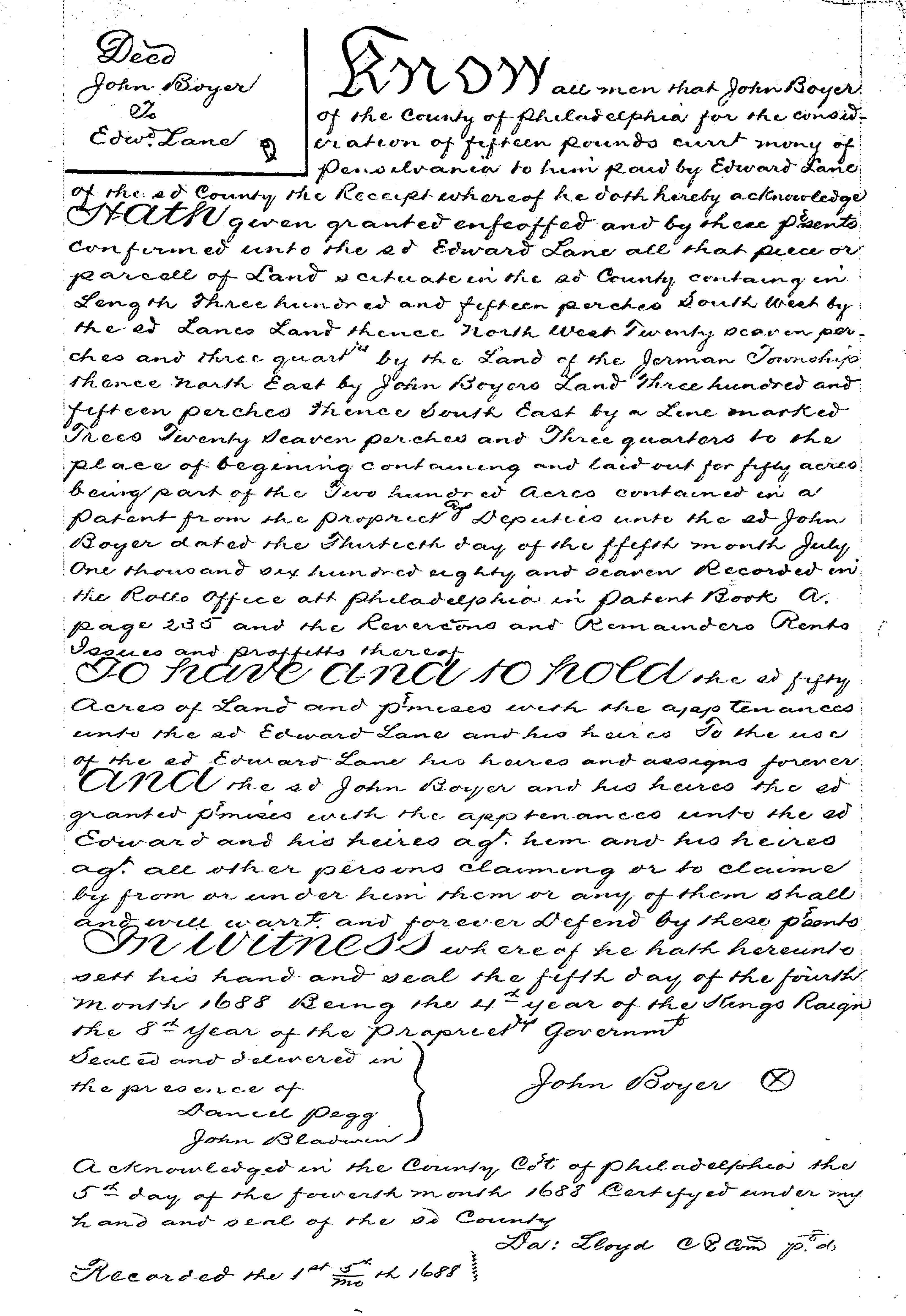
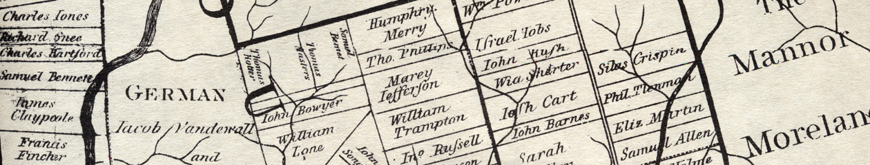
For example, who were the widow Bond, John Bye, Drawell, Daniel Hough, and John Swart? With some research, these were found to be the widow of John Bond, the First Purchaser John Boy, Joseph Drake the 1683 emigrant, John Hough of Darby (not Daniel), and Jan Classen the horse trader who was known by different names. About fifty of the people on the map required this extra level of analysis.

That leaves a few genuine puzzles: names that don’t match any known records. We have to assume that these were errors, either by Holme or by the engraver in London who had no personal knowledge of the people. There are five of them: John Denne, John Eluny, Free School, Widdow, and William Jones. John Denne is shown on the map in Whitpain township with John Goodson. There were several men around named John Dennison or Denning or Densey, but none of them can be tied to this land in Whitpain or to the physician John Goodson. John Eluny is shown in Westtown next to Francis Yarnall; there are no records of any Eluny at the time, and no land records that give a clue who this might be. The tract marked Free School is in Chester Township. There are no records of land being set aside for a school at this time. The only owner near there was Richard Few, so perhaps this was an error for his name. Widdow is on the map in Edgmont. When Holme showed the land of a widow he always included her surname, for example the widow Hurst or the widow Shorter. There was a William Findlow who bought land in Edgmont in 1687, but this seems late to make it onto the map, though it was in about the right place. Finally, there is the problem of William Jones. There were men around named William Jones, but none of them can be tied to this land in Newtown. Smith’s Atlas of Delaware County shows this land as belonging to Robert Dunton. Did one of the men named William Jones acquire the land from Dunton? These are puzzles that cannot be answered yet, possibly not at all, given available records.

Land records: If your ancestor bought land from someone else

If you have an early Pennsylvania ancestor, he or she might have bought their land from William Penn or from someone else. If they bought from someone else, the record will not be found in the Old Rights Index, as discussed in If your ancestor got land from William Penn. Instead the record might be found in an early deed book. There is no guarantee of this. There was a fee for recording deeds, and some people did not bother. On the other hand, land was vitally important to people, and many deeds were recorded.

The earliest deeds for Chester County were recorded in Philadelphia, until 1714, when Chester set up its own recorder. For Bucks County deeds were recorded from the earliest years. Although some people may have chosen to record theirs in Philadelphia, most will be in Bucks county.

The early deed books for Philadelphia city and county are available on microfilm, at the Philadelphia City Archive and at the Historical Society of Pennsylvania. To find the deed, you need to know the deed book and page. There is an online index for both grantors and grantees, unwieldy to use. James Duffin has prepared a detailed guide for using it. Once you find the deed book and page number, you can look for the text of the deed itself, either on the microfilm or online, by subscription only, at the Historical Land and Vital Records site of the Philadelphia Department of Records. Duffin’s guide covers how to use this as well.

When you find a deed, what will it tell you? Here is an early example. Deed book 10 image 20 cropped

In 1688 John Bowyer (in the deed as Bower) sold a piece of his land to Edward Lane. It was a tract of 50 acres, out of Bowyer’s tract of 200 acres; Lane paid £15 pounds for it; it lay next to Germantown; Bowyer signed it on the 5th day of the 4th month in 1688; it was acknowledged in county court the same day. You can’t tell from a deed whether the grantor or grantee lived on the land, although you can tell whether it had a house or other improvements (this tract did not) since those are described in the deed if they exist. You can often find the occupation of the grantor and grantee, although not in this example. If the land was a gift, sometimes given “for love and affection”, instead for money, it suggests a family relationship.

The deed by itself may not be informative, but you can put it together with other pieces to form a picture. If you look at Thomas Holme’s county map, to the east of Germantown, you will see John Bowyer and William Lane. William was Edward’s father, a grocer of Bristol, England and a First Purchaser in 1681. William did not emigrate, but Edward emigrated and took up the family land. When Edward married Ann Allen in 7th month 1688 he was described as of Philadelphia County, suggesting that he was living on the land (rather than on his city lot). 1 The land lay in Bristol township; often the townships were named for the place in England where people came from. Lane was not the only landholder in Bristol from Bristol, but his tract, along with John Barnes’, was one of the largest in the township, so it may have gotten its name from his home place.

For Chester County, most deeds  were recorded in Philadelphia until 1714, but there were some in Chester. There is an online index for deeds to 1850 at the Chesco site. The deeds themselves are at the Chester County Archives in West Chester. A published source by Carol Bryant, Abstracts of Chester County Land Records, in two volumes, has good abstracts of deeds, including price paid, size of the tract, and names of adjoining landowners.

For Bucks County, deeds were recorded starting in 1684. The originals are on microfilm at the Bucks County Courthouse in Doylestown. The index is available at the courthouse in bound volumes. There are two published sources for abstracts of early deeds: John Davis, Bucks County Pennsylvania deed Records 1684-1763, and Charlotte Meldrum, Abstracts of Bucks County Pennsylvania Land Records 1684-1723. They cover the same transactions; Meldrum provides more details. Davis did not understand the Quaker dating system; his months are incorrect. For example, on page 3, Davis gives: “Patrick Kelley husbandman of Phila bound to Philip Conway, war master of Bucks County. Witnessed by Silas Crispin, Tryall Holme and Edmond McVagh. March 29, 1686”. This was actually on 3rd month 1686, as Meldrum indicates. And of course Conway was not a war master, but a farmer who lived in Warminster! 2 Use these abstracts with care, and refer to the originals for transactions essential to your research. 3

  1. Marriages recorded by Bucks Quarterly Meeting.
  2. To be fair, Meldrum has errors too, for example on page 18 when she has Luke Brindley adjoining “Audry Elred”, for Anthony Ellard.
  3. This transaction, a loan from Conway to Kelley, is interesting, as all five of the men involved were Irish. Conway, later kicked out of the province for horse theft, was married to the daughter of Ann Milcom from Armagh. Crispin was married to Thomas Holme’s daughter; Edmond McVeagh was a servant of Holme’s who came over with him. Tryall was Thomas Holme’s son, later lost in a sea voyage.

Land Records: If your ancestor got land from William Penn

If your ancestor emigrated to Pennsylvania in the earliest year of the province and owned land there, he or she might have bought the land directly from Penn. To find the records, you need to look for warrants (orders to lay out the land), surveys (a map showing the land) or returns (a verbal description of the land). These were all created at the time, but many papers did not survive. They were kept in various offices around Philadelphia in bins or bundles or bushels by the Surveyor General and the Secretary of the Land Office, who in the earliest years did not keep organized offices.

At various times the records were organized and listed, in 1698, 1759 and again in 1833. These lists mostly survive and are most or less accessible, and they don’t completely overlap. The most accessible are the 1833 copies, recopied in 1909 and put online at the website of the PMHC, the Pennsylvania Historical and Museum Commission. This trove of thousands of pages holds many treasures. The primary documents here are the Copied Survey Books. In spite of the name they are a mix of document types: warrants, returns, petitions, caveats, orders. They are not in an organized order (although the older ones mostly cluster around D61 through D89.) Fortunately there is an index for the transactions before 1733, called the Old Rights Index. It is roughly alphabetical, with multiple pages to search for each letter. You need to keep in mind as you use it that the dates are systematically wrong.

The clerks who copied the list in 1833 apparently did not understand the early date system, where the year started in March instead of January.  Since the Quakers numbered the months instead of using names, the clerks saw 1st month, 2nd month, etc, and mistook 1st month for January, when it should have been March. The 12th month is February, not December, and so forth. An example of the error: Thomas Ellis received a warrant in 11th mo 1687/88. 1 This would be February 1688 in our dates. The clerks wrote it November 1687/88 in the Old Rights Index. 2

To find a document in the Copied Survey Books, start with the Old Rights Index. Suppose your ancestor was James Boyden, an early settler in Bucks County. In the Bucks County Old Rights Index, following the link for the B names, you find two entries for Boyden.

Bowden in ORI

One is listed as a return (actually a warrant), the other as a survey. The dates on both are wrong, by the usual two months. To see these documents, follow the link on the PMHC overview page for Images of all surveys. Go to book D72, page 101 to see the warrant. Penn ordered Holme to lay out 500 acres for Boyden, also his land in the Liberties, to be settled within one year under the usual conditions. Holme must have been busy in the summer of 1684, since by his note at the bottom he didn’t order Israel Taylor to do the survey until four months later. Oddly enough Boyden already had his land, had probably been settled on it for two years when this warrant was issued. If you look at book B22, page 4, you see the 1682 survey, made by Richard Noble, a beautiful map with accompanying description. Boyden’s land lay on Neshaminy Creek, with marshland on two sides, the King’s Road running through it, an Indian path touching at one corner, and a horse-trading Dutchman as one of his neighbors. To find the order for this survey, you have to page through the B section of the Old Rights Index to the end, to find an unnumbered listing for James “Boyd”, 900 acres, D82, 106. This leads to an order from Thomas Holme to Richard Noble in 7th mo 1682. There are several morals here: be persistent and read all the pages that might include your ancestor; don’t expect all the documents to still exist and match up neatly; remember that the spelling of names was inconsistent.

For another take on the early documents, you can look at the list made by John Hughes in 1759, an earlier version of the Old Rights Index. The 1833 clerks used this as the basis for their list, adding the numbers for the Copied Survey Books. Hughes gathered the original documents, sitting in bundles in Philadelphia, some eaten by mice, and copied them  neatly into Warrant and Survey Books, and made the Old Rights Index as an index to them. Unfortunately the Warrant and Survey Books exist only in fragments, gathered and rebound. 3 The Old Rights Index that Hughes made was published in the Pennsylvania Archive in Series 3, volumes 2 and 3. Since this does not have the Copied Survey Book numbers (because they were not added until 1833), it is not particularly useful unless you need to check dates or have trouble deciphering a handwritten name. 4

Further guides to the land records:

  1. Copied survey book D77, 69.
  2. One complication is that some of the early officials were inconsistent, sometimes using Quaker numbered months and sometimes using pagan month names. To be confident of the exact date you must check the original document in the Copied Survey Books. Note that writers like Penn sometimes used 9br as shorthand for November and 10br for December.
  3. The Historical Society of Pennsylvania has microfilm of what remains, with a published index made in 1975. The books themselves are at the Philadelphia City Archives and in Harrisburg.
  4. Similarly the 1698 list of warrants and returns, available in the Roach mss collection at the HSP, does not add any information to the Old Rights indexes and Copied Survey Books.

Land Records: converting rights into land

Someone who owned land in early Pennsylvania got it in one of three ways: buying it from William Penn, buying it from someone else, or inheriting it. A very few people also got land as a gift from Penn; it helped to be related to him or his wife. 1 This post will discuss the process of buying land from Penn.

Some people, mostly Friends, bought rights to land from Penn before he emigrated in 1683. These people are called First Purchasers. Most of them were entitled to a city lot and land in the Liberties by virtue of their purchase. They did not buy land in a specific place, but rather the right to have their acreage laid out for them. Many of them emigrated and settled on their land, but others sold their rights to others. In either case people held rights that they could bring to Pennsylvania and convert into land.

When someone arrived with rights to land and wanted to have the land laid out, they went to William Penn in Philadelphia (or his Commissioners after he went back to England in 1684), showed him their deed, and requested their land. On this request, Penn or the Commissioners would issue a warrant to Thomas Holme, the surveyor general, to lay out the land. A typical warrant would look like this:

“William Penn, Proprietor and Governor of the province of Pennsilvania and the territories thereunto belonging. At the request of Joseph Willard in right of his brother that I would grant him to take up his City Lotts where they fell to build upon it. These are to will and require thee forthwith to survey or cause to be survey’d unto him the Lotts proportionable to his Purchase; and make returns thereof into my secretary’s Office. Given at Philadelphia, the 8th 9br 1683. William Penn. For Thomas Holme, surveyor general.” 2

Note that Joseph’s brother George was the actual purchaser and that Joseph was requesting based on George’s right. (George was a First Purchaser of 1250 acres.) Also note that city lots were laid out in different sizes depending on the size of the purchase; 1250 acres was above the average. 3

Once the warrant was in Holme’s hand he could either survey it himself or pass the job on to one of his deputy surveyors. In either case, once the survey was done, a return was filed with the secretary. A return was a description of the land, where it was located and how many acres it contained. A typical return would look like this:

“By the Surveyor General’s order pursuant to two warrants from the Commissioners dated the 10th of the 12th mo 1684 and the 11th of the 6th mo 1685 I certify that I have surveyed unto Denis Roachford [Rochford] a certain Tract of Land scituate att Moose Lickamickon begining at a post in the line of the land of John Barnes thence northeast by the same and other lands 960 perches to a large oke [oak] marked for a corner thence northwest by vacant land 700 perches to a large hickrey marked for a corner then southwest by vacant land 960 perches to a white oke for another corner thence southeast againe by vacant land 700 perches to the place of begining qt [quantity] 4200 Acres the 15th 6th mo 1685. Tho Fairman surveyor.” 4

This description of the boundaries is called the metes and bounds. Note that they spell out exactly where the land is, if you can find the post on the line of John Barne’s land. (It would be somewhere near the boundary of modern-day Hatfield and Montgomery townships in Montgomery County.) A perch was a unit of both acreage and length. Seven hundred perches is just over two miles. This was a very large tract.

Along with the return the surveyor would make a survey, a map showing the land, adjoining landowners. Here is a sample survey, from the later copies available online. 5

Book D-79 pg 99 survey

Note that the copyist in the 1800s had the usual trouble with the name of Philip Theodore Lehnmann, creating a non-existent Thlamaine. This tract was typical of one fronting the navigable rivers, with a short strip along the river, extending backwards from there. There was no date on this survey; it may have been done in 1682. He mentioned it in his will in early 1686.

The survey was returned to the Surveyor General’s office, along with the return. The purchaser did not keep it; at this point he had no written proof that he owned the land. 6 The Surveyor General was supposed to check the survey to make sure it laid out the proper number of acres, and to keep it on file in his office.

The final step in the process was for the landowner to apply for a patent. This was the written proof that he owned the land. It included the description of the metes and bounds, and the legal text indicating ownership. Here is a sample of the patent for Mary Southworth’s city lot.

William Penn… Governor… to all to whom these presents shall come sendeth greeting: Whereas there is a certain lott of land in Philadelphia scituated in the third street from Delaware [river] containing in breadth forty nine foot and a half and in length two hundred fifty five feet bounded northward with Chestnut Street, eastward with Thomas Rouses land… granted by warrant from myself bearing date the 6th day of the 4th month 1684 and laid out by the Surveyor General order… unto Mary Southworth… Know ye that I have given granted and confirmed by these presents… Mary Southworth her heirs and assigns forever… paying one English silver shilling… 31st 5th mo 1684. Recorded 7th 6th mo 1684. 7

Note that Mary owned the land outright and could bequeath it to her heirs or sell it to someone else, but she had to pay a quitrent of one shilling per year to Penn. 8 9

The next post will show how to find the early land records: warrants, surveys and patents.

  1. Penn did make a few gifts of land to others, such as John Aubrey, who wrote in 1686 that William Penn gave him 600 acres in Pennsylvania “without his seeking or dreaming of it”. (Memoir of John Aubrey, by John Britton). Penn, a member of the Royal Society, though no scientist, admired Aubrey’s work.
  2. Pennsylvania Historical and Museum Commission Archives, online at http://www.phmc.pa.gov/, Land Records, Copied Survey Books, Book D-80, page 43 (image 85).
  3. The month name 9br referred to the ninth month—November—since prior to 1752 the year started in March.
  4. Copied Survey Books, D-86, page 191, image 96
  5. Copied Survey Books, D-79, page 99, image 50
  6. Donna Munger, History and Guide for Pennsylvania Land Records, p. 46.
  7. Exemplification Book 1, Philadelphia City Archive.
  8. Penn used these rents, widely resented and often not paid, to raise revenue in lieu of taxes. The Blackwell Rent Roll was an attempt to catalog the rents due, in hopes of collecting them more systematically.
  9. Mary’s brother John Southworth was an apothecary and clerk of the Philadelphia monthly meeting.

Quaker certificates of removal

The early Quakers used certificates as a way to introduce themselves to strangers. When they left their home meeting to emigrate and join a new meeting, they needed to show proof that they were members in good standing, of good behavior, and for the unmarried, clear of marriage promises or “entanglements”. The Quakers were fastidious about not allowing young people to marry if they had any prior promises or engagements to others.

The meetings in Pennsylvania sometimes had to remind the English or Welsh meetings to send the certificates. A certificate presented to Radnor meeting in 4th month 1684 for Sarah Hearn began with, “In as much as we have seen an order from you of Pensylvania in order to keep out all disorderly spirits of persons professing the same truth with us and you; that all which came from England to you or from you to us should bring some certificate or signification…”

Although the certificates were considered very important, the procedure for recording them was not standardized. The meeting that issued the certificate sometimes kept a record of them and sometimes did not. There might be a note in the minutes that someone had requested a certificate, and that one was written out for him or her, but there was not usually a copy kept on record. The certificate was written out for the traveller to keep.

What did people do with them? They were supposed to present them to their new meeting when they arrived, although some meetings were more diligent than others in requesting them. The men’s meeting at Concord realized in mid-1687, after they had been meeting for five years, that they had not asked for certificates from their members. They ordered members to bring in their certificate or “verble testimony of friends that live hear [here] of their good lives and conversations in old ingland”. 1 The minutes show that most members complied within a few months. Once in a while people were asked to send back to England for a certificate, either because they never got one or because it did not state clearly that they were free to marry. 2

What was in the certificates? There was no standard form. Some were brief notes, almost “To whom it may concern…”, while others were flowery, like short religious tracts. A typical one might read like the one David Brentnall presented to the monthly meeting in Philadelphia. “10th day of the 8th mo 1681. These are to certify to Friends at London or to whom it may concern that David Brentall of late belonging to our meeting in Derby-Shire called by the name of Breach meeting: We whose names are here subscribed doe give in our testimony according to our knowledge that since the time that he amongst Friends he hath behaved himself soberly as become the truth, and that he is gone away cleare from all Accounts; and as touching the young man Friends had more than an ordinary Respect for him by Reason of his honest Behavior amongst us: And for a particular Account from the Friends where he boarded while he continued with them he had by his Civil Behaviour gained so much upon them that they had a great Respect for him, and are desirous of his well doeing, whose names are here subscribed.” It was signed by 18 Friends, men and women, including some who later emigrated themselves, like John and Michael Blunston, Luke Hank, and Frances Cooke. 3

Why would you want to see them? Certificates show where someone lived before emigrating. They show the approximate date of emigration, since certificates were usually issued a month or so before departure. For a married man, the certificate might show the name of his wife and children, although not always. If you can find the full certificate, it is always worth looking at the names of the people who signed it, as they are sometimes family members. For example, the certificate of Ralph Fretwell from Barbados in 1683 was signed by Thomas Fretwell.

The early certificates are available in various forms (abstracts or full text) and in various places (on Ancestry’s Quaker Records collection, in published books of records, on microfilm at the Friends Historical Library, and in the church record volumes at the Historical Society of Pennsylvania.

Here are some sources for the earliest monthly meetings:

MeetingAncestry (Quaker Collection)Published sourcesHistorical Society of Pennsylvania
Falls"Minutes 1682-1743", a list, not abstracts or full certificates. Early Church Records of Bucks County, volume 2, edited by Watring and Wright, has short abstracts.The best source for full certificates, call numbers Bu 1F:2 and Bu 1F:4.
Middletown“Minutes, marriages, certificates of removal…”. Also Philadelphia Arch Street meeting, “Record of certificates of removal 1682”Early Church Records of Bucks County, volume 2, has some listed. Not in the table of contents, they start at page 239.
Philadelphia“Removals 1681-1758”, a good source for full certificates, Watring’s Early Quaker Records of Philadelphia, volume 1, has a list, not the full certificates. Albert Cooke Myers, Quaker Arrivals at Philadelphia, is also a list. Gilbert Cope’s transcription, call number Ph 1F:5, probably from the same manuscript as “Removals 1681-1758”, a good source
AbingtonNo separate list known. Look for some of their members in the early arrivals at Philadelphia MeetingNone knownNone known
Radnor“Births, deaths, marriages, certificates of removal (received), 1683-1730”Early Church Records of Delaware County, volume 3, edited by Launey, has abstracts, in alphabetical order, to about 1730.Gilbert Cope’s copy at call number De 15F:1
Chester“Register Book 1681” is a mix of early subscriptions, marriages, births, burials, certificates, and payments. The certificates are on images 13 and 14.None in Early Church Records of Delaware County, volume 1.
ConcordNone knownNone in Early Church Records of Delaware County, volume 2.Included with other records, call number De 9F:2.
Darby“A few certificates… 1684-1763” has full certificates of some early arrivals.Early Church Records of Delaware County, volume 3, has a list showing date and originDe 13F:1 (in alphabetical order)


  1. Concord men’s minutes, 9th month 1687, available on Ancestry’s Quaker Records collection.
  2. Once in a while a certificate turns up in an odd place. When Jeffery Hawkins presented himself to William Penn in 8th month 1682 to claim his headright, he must have handed his certificate of clearness to Penn, who added a note at the bottom to Thomas Holme directing him to lay out the land. (Copied Survey Books, D-74, page 207, image 415)
  3. On Ancestry’s Quaker records collection, Philadelphia Monthly Meeting, Removals 1681-1758, image 26.