If your ancestor emigrated to Pennsylvania in the earliest year of the province and owned land there, he or she might have bought the land directly from Penn. To find the records, you need to look for warrants (orders to lay out the land), surveys (a map showing the land) or returns (a verbal description of the land). These were all created at the time, but many papers did not survive. They were kept in various offices around Philadelphia in bins or bundles or bushels by the Surveyor General and the Secretary of the Land Office, who in the earliest years did not keep organized offices.
At various times the records were organized and listed, in 1698, 1759 and again in 1833. These lists mostly survive and are most or less accessible, and they don’t completely overlap. The most accessible are the 1833 copies, recopied in 1909 and put online at the website of the PMHC, the Pennsylvania Historical and Museum Commission. This trove of thousands of pages holds many treasures. The primary documents here are the Copied Survey Books. In spite of the name they are a mix of document types: warrants, returns, petitions, caveats, orders. They are not in an organized order (although the older ones mostly cluster around D61 through D89.) Fortunately there is an index for the transactions before 1733, called the Old Rights Index. It is roughly alphabetical, with multiple pages to search for each letter. You need to keep in mind as you use it that the dates are systematically wrong.
The clerks who copied the list in 1833 apparently did not understand the early date system, where the year started in March instead of January. Since the Quakers numbered the months instead of using names, the clerks saw 1st month, 2nd month, etc, and mistook 1st month for January, when it should have been March. The 12th month is February, not December, and so forth. An example of the error: Thomas Ellis received a warrant in 11th mo 1687/88. 1 This would be February 1688 in our dates. The clerks wrote it November 1687/88 in the Old Rights Index. 2
To find a document in the Copied Survey Books, start with the Old Rights Index. Suppose your ancestor was James Boyden, an early settler in Bucks County. In the Bucks County Old Rights Index, following the link for the B names, you find two entries for Boyden.
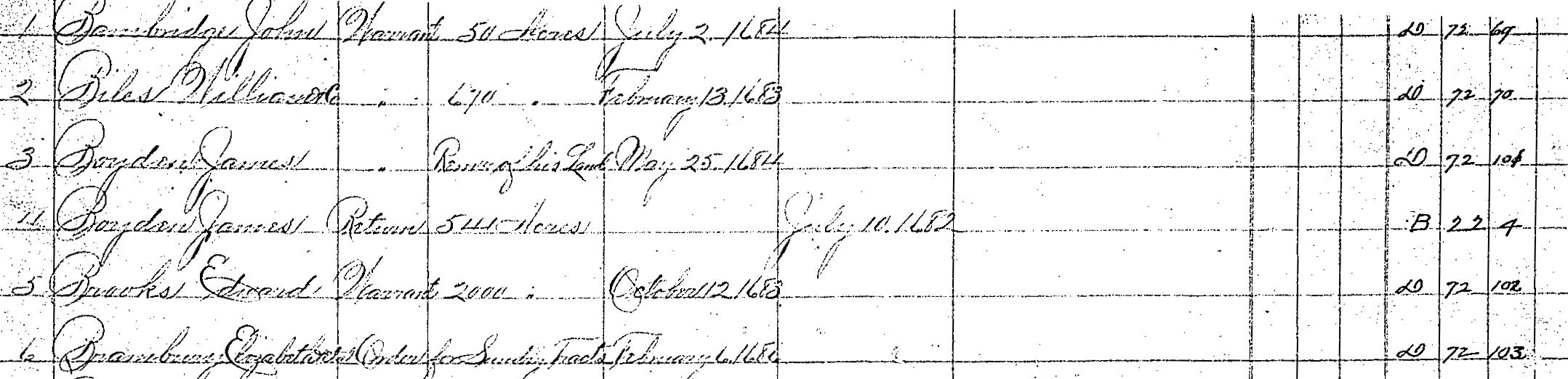
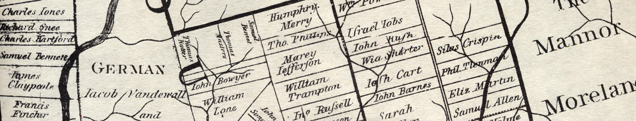
One is listed as a return (actually a warrant), the other as a survey. The dates on both are wrong, by the usual two months. To see these documents, follow the link on the PMHC overview page for Images of all surveys. Go to book D72, page 101 to see the warrant. Penn ordered Holme to lay out 500 acres for Boyden, also his land in the Liberties, to be settled within one year under the usual conditions. Holme must have been busy in the summer of 1684, since by his note at the bottom he didn’t order Israel Taylor to do the survey until four months later. Oddly enough Boyden already had his land, had probably been settled on it for two years when this warrant was issued. If you look at book B22, page 4, you see the 1682 survey, made by Richard Noble, a beautiful map with accompanying description. Boyden’s land lay on Neshaminy Creek, with marshland on two sides, the King’s Road running through it, an Indian path touching at one corner, and a horse-trading Dutchman as one of his neighbors. To find the order for this survey, you have to page through the B section of the Old Rights Index to the end, to find an unnumbered listing for James “Boyd”, 900 acres, D82, 106. This leads to an order from Thomas Holme to Richard Noble in 7th mo 1682. There are several morals here: be persistent and read all the pages that might include your ancestor; don’t expect all the documents to still exist and match up neatly; remember that the spelling of names was inconsistent.
For another take on the early documents, you can look at the list made by John Hughes in 1759, an earlier version of the Old Rights Index. The 1833 clerks used this as the basis for their list, adding the numbers for the Copied Survey Books. Hughes gathered the original documents, sitting in bundles in Philadelphia, some eaten by mice, and copied them neatly into Warrant and Survey Books, and made the Old Rights Index as an index to them. Unfortunately the Warrant and Survey Books exist only in fragments, gathered and rebound. 3 The Old Rights Index that Hughes made was published in the Pennsylvania Archive in Series 3, volumes 2 and 3. Since this does not have the Copied Survey Book numbers (because they were not added until 1833), it is not particularly useful unless you need to check dates or have trouble deciphering a handwritten name. 4
Further guides to the land records:
- The HSP guide to land records: good background and a glossary
- Family Search wiki page on Pennsylvania land: packed with information
- Ancestor Tracks on land documents (various links)
- Kris Hocker’s excellent guide to using the online land records
- Copied survey book D77, 69. ↩
- One complication is that some of the early officials were inconsistent, sometimes using Quaker numbered months and sometimes using pagan month names. To be confident of the exact date you must check the original document in the Copied Survey Books. Note that writers like Penn sometimes used 9br as shorthand for November and 10br for December. ↩
- The Historical Society of Pennsylvania has microfilm of what remains, with a published index made in 1975. The books themselves are at the Philadelphia City Archives and in Harrisburg. ↩
- Similarly the 1698 list of warrants and returns, available in the Roach mss collection at the HSP, does not add any information to the Old Rights indexes and Copied Survey Books. ↩
Thank you for the link to my site for this record set. I’m thrilled you found my explanation of the records “excellent.”