Category Archives: Holme’s map

Early owners of Abington township

When the English Quakers came over in fifty boats in 1682 and 1683 they settled in Philadelphia and in an arc of rural townships, from Chester County through Philadelphia County and eastward to Bucks County. Abington township lay in the middle of this arc. It was good farmland, well-watered by streams and creeks, and not too far from Philadelphia, an important feature for farmers who might take their surplus to the market to sell. It was also the seat of Abington Monthly Meeting, one of the earliest, largest, and most influential of the Quaker meetings.

Abington was typical of the townships settled early by English Quakers. It was not a “linear village” like Germantown or a proprietary manor like Springfield. It was not owned by a single purchaser like Nicholas More’s Manor of Moreland, nor was it dominated like a single family like the Growdens in Bensalem. Instead Abington, like many townships in lower Bucks and Chester Counties, was cut up into tracts for the first purchasers, most of whom bought their land in England from William Penn in 1681. At first the land in the township was owned by these early purchasers, but as the years passed, it was divided into smaller tracts. Some of the early purchasers did not settle on their tracts, but bought them as speculation. They settled instead on lots in the city, if they came to Pennsylvania at all. Of those who immigrated, some lived on their city lots; some sold them and lived in the country. As we will see, the early owners of Abington were a mix of immigrants and speculators.

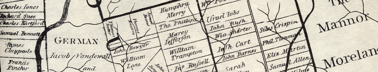
The township was not originally called Abington. When Thomas Holme made his map in 1687, it had no name. In early deeds it was described as “the county of Philadelphia” or sometimes “Pemmapecca” (by any of several creative spellings). Holme drew a dotted line across his map dividing it into a northern and southern half, suggesting that it was originally meant to be two townships. The upper half was sometimes called Hilltown, and the lower half was sometimes called Dublin. When the township boundaries were finally laid out, Abington was formed from Hilltown and the northern part of Dublin, while the remainder of Dublin became Lower Dublin.[1] Abington township is quite large compared to other townships, over 10,000 acres. It touches Cheltenham, Upper Dublin, Moreland, and Lower Dublin, and touches (or almost touches) Springfield, Horsham and Oxford at the corners.

Pennypack Creek flows south through much part of Abington, crossing from Moreland and flowing south and southeast on its way to Lower Dublin and the Delaware River. It is a strong flowing stream and in the 1700’s was dotted with mills. Frankford or Tacony Creek also flows through Abington, on a path parallel to the Poquessing and west of it, through Cheltenham and so down to the Delaware. One large tract in the middle of Abington, originally Sarah Fuller’s land, had streams that drained into both the Frankford and the Poquessing Creeks.

Who were the first purchasers in Abington? They were an interesting mix—Wasey  the sea captain captured by Barbary pirates, Clarridge the Irish lecher, Lehnmann the careless secretary, Mary Brodwell the midwive who lived to be a hundred, Elizabeth Shorter the glover, John Rush her deceitful son-in-law, the good Quaker farmers and the sharp-dealing Quaker merchants. By studying early records—land deeds, Penn’s letters, minutes of the Council, and more—we can find the stories hidden behind the names on the map. The next post will begin to tell those stories.

[1] The township of Upper Dublin lies north of Abington and, confusingly, does not touch Lower Dublin. The two Dublins were not derived from subdivision of one township, and currently lie in two different counties. When Montgomery County was split from Philadelphia County in 1784, the county line was run between Abington (in Montgomery) and Lower Dublin (in Philadelphia).

The people on the map: What was their religion?

Religious affiliation is more difficult to categorize than occupation or immigration. Affiliation could change over time, as when some Quakers followed George Keith in 1692 and became Baptists or Anglicans. And it was not always recorded. The Quakers were the only group with surviving early records. If someone does not appear in the Quaker records, does that mean that they were not Quaker, or simply that they were not active in the meeting?

Evidence for religion comes from Quaker meeting records, burial records of non-Friends, wills (for example, those with bequests to other churches). sometimes by association with people of known affiliation, like the Dungan family of Baptists.

Certain assumptions are reasonable. The Swedes were overwhelmingly Lutheran, many attending the church at Wicaco, later Gloria Dei. There were known Anglicans in the province, such as William Markham and George Foreman. There were people whose behavior shows that they were not Friends, like Gilbert Wheeler the unruly innkeeper.

Using available evidence, religious affiliation was classified into Quakers, Lutherans, Unknown, and Other, a category that included Baptists, Anglicans, and the occasional Catholic. As the table shows, the people on the map were predominantly Quaker.

ImmigrantsNon-immigrantsSwedesTotal
Quaker418740492
Lutheran104142
Other3814254
Unknown190019
Total4768843607

Does this mean that the people in the province were predominately Quaker? The answer is no. There were many people missing from the map who show up in court records, wills, and land records, and many of them were not Friends. Since the Quaker meeting houses were too small to hold the population, even in the early years, it is clear that many people in the province were unchurched.

The people on the map: Where were they from?

The people on Holme’s map were from many of the same regions as Quakers in general, even though they were not all Quaker. The evidence for origin comes from land records,especially for First Purchasers and people who sold their land while still in England, English Quaker records, certificates of removal, and a smattering of other sources.

Because of the particular records that give place of origin, we know the origin of almost all who did not immigrate. Many of them were First Purchasers. Those who immigrated appear in many records, most of which don’t show origin. This is the same pattern as for occupation.

The map shows the pattern of emigration. 1

Map of origins

The cities of London and Bristol provide many of the people, especially the merchants. Many of the farmers and artisans came from a few counties, especially Cheshire and Wiltshire. There were few from East Anglia; that was Puritan country. 2 Some of the clusters reflect patterns of immigration. For example a cluster from Derbyshire ended up in Darby township, Delaware County. More analysis would probably show more clusters like this. And of course the Welsh predominately settled in the Welsh Tract.


  1. Adapted from Dunn and Dunn, Papers of William Penn, volume 2.
  2. See David Hackett Fischer’s informative work, Albion’s Seed, for more on regional differences.

The People on Holme’s map: What were their occupations?

The next question about the people on Holme’s map is about their occupations. How did they support themselves and their families? The evidence for occupation comes from many sources—primarily deeds and wills, but occasionally from other places such as letters. For some of the people, almost a quarter of the total, their occupation is unknown. In many cases it can be presumed to be farming, but they are not counted as farmers unless they are actually described this way in a record.

When we break down the numbers of people on the map by occupation and whether they immigrated or not, we see an interesting pattern. Many of the gentlemen and merchants did not immigrate; their interest in the colony was as investors or supporters of Penn’s vision. Many of the artisans and farmers, the “middling sort”, did immigrate. They formed the backbone of the colony—the largest single group. These were the people whom Penn had hoped to attract when he advertised the colony. The Swedes, who were neither immigrants nor non-immigrants, but in a category of their own, were generally farmers.

It may seem paradoxical that more of the occupations are unknown for the immigrants than the non-immigrants. (As will be seen, this is also the pattern for their origins.) This is a result of the records available for them. Many of the non-immigrants were First Purchasers, whose origin and occupation were given in their deed of lease and release from Penn. Many of the immigrants were not First Purchasers; they were late purchasers of land from Penn or bought rights or land from others. The records that include them, such as church or court records, typically do not specify occupation.

Here are the occupations, broken out by immigration status.

ImmigrantsNon-immigrantsSwedesTotal
Women233127
Artisans112160128
Farmers111521137
Gentlemen1621037 (inc 3 women)
Merchants6129292
Services22000
Other236130
Unknown108918135
Total4768943608

There are several interesting points here. As already noted, merchants and gentlemen did not immigrate at the level of farmers and artisans. It might be surprising that so many farmers immigrated, since they would seem to be tied to their land. Obviously many Quaker farmers found a way to leave their land in England (or Ireland or Wales) and start over a new place. The climate in Pennsylvania was comparable, though more extreme, than that of England, but their skills would have served them well. Another interesting point concerns the Swedes. They would have needed some services, such as milling and blacksmithing, and in fact they had a mill, but the names of people who provided those services are unknown. Perhaps some of the Swedes whose occupations are unknown were in fact millers or smiths. Finally, many of the women, especially the widows who headed households, probably engaged in farming, as discussed in the post on classification, though they were never described that way. When women appear in a will or deed they are described by their status, not their occupation. So strong is this status identification for them that some women on the map are described only as “Widow Bond” or “Widow Hurst”. To our modern eyes they are denied the dignity of a given name.

Next: Where were the people from?

The people on Holme’s map: Classifying their occupations

The occupations of Pennsylvania in the 1680s fall into six categories: artisans, farmers, merchants, gentlemen, service providers, and others. These categories are for the men on the map. The women are a special case and get counted separately.

Artisans were people who made things. Carpenters, tailors and shoemakers were the most common, along with maulsters who made beer. John Bowyer was a shipwright. Some of them had occupations in England that would been irrelevant in the new world; Edmond Bennet had been a tobacco cutter in Bristol but probably became a farmer in Bucks County.

Farmers included those who called themselves yeomen or husbandmen. These names had meant different things in England. For example a yeoman owned his own land. But in early Pennsylvania the terms seem to be used interchangeably. It is important to note that even most people with other occupations such as artisans and millers also carried on farming. That is, they lived on substantial plots of land and raised crops for their family, even while earning income in other ways. 1

The term merchant covered everyone from wealthy men like Samuel Carpenter who traded with England and the West Indies, to those who kept a small shop and sold dry goods and groceries. To be called a merchant was a status symbol. No one described himself as a shopkeeper, but there must have been many, in both the city and the countryside.

Gentlemen did not have to work for a living. The Penn family, his relatives the Lowthers, wealthy merchants—they lived on income from investments and rents. Thomas Hudson of Macclesfield, Chester, was a land speculator who bought 5000 acres, sent his servants in 1685 to have the land laid out, did not immigrate. Richard Ingelo came on the Welcome with Penn, served as clerk of the council, went back to England in 1686 when he inherited property there. Like merchant, gentleman was an term of aspiration; some prosperous farmers described themselves as gentlemen in their wills.

Some men (and one known women) provided  a service: blacksmiths, millers, innkeepers, carters, ferrymen, midwife. These were essential, and in the case of ferrymen, sought-after positions. The council granted the Schuylkill ferry rights to Philip England, but in 1693 William Powell tried to muscle into the business and was rebuffed by the council. Innkeepers were supposedly licensed, frequently in trouble for selling beer without a license, frequently in trouble for selling rum to the Indians. The one known midwife was Mary Bradwell, who lived to be a hundred and named great-grandchildren in her will. There must have been other midwives whose names were not preserved.

Some occupations are unusual and form a mixed group: the Swedish minister, doctors, surveyors, clerk, schoolmaster, mariner. Except for the mariner, this would be called a white-collar group. They were probably all literate. But some of them were also probably farmers. For example, John Southworth was the clerk for Philadelphia County in 1683 but also owned 500 acres of land.

The women on the map are a special case, when considering occupation. Of the 34 women on the map, only a few were wealthy enough to live on their income, such as Gulielma Penn and Margaret Lowther. Of the others, 21 were widows, including 8 who were widowed during the voyage or immediately after. These women would need to support themselves and their families with their main asset—their land. Although women were never described as farmers, many of them must have hired laborers (or had adult sons) to run a farm.

Next: The results for occupation

  1. Remember that the income was probably not money as we think of it. Currency was scarce in the early days, as Pennsylvania was not allowed to mint its own coin, and many payments were in “country currency” like a bushel of wheat.

The people on the map: did they immigrate?

Identifying the names on Thomas Holme’s map of the three counties required matching them to records from the time: church, land, court, immigration, probate, and more. Once that was done, the records were studied to see if they formed a pattern to match a single person. Of the 600-plus unique names on Thomas Holme’s map, 608 can be identified in this way. 1

With the people identified, we can answer questions about them. Did they immigrate? What were their occupations? Origins? Religious affiliation? Some of these are straightforward, others trickier to define.

The question of immigration is straightforward, and the evidence is usually clear. Evidence for immigration comes from any record that shows them living in Pennsylvania: a deed, a will, church records such as Quaker meeting minutes, signing a petition such as the tax protest of 1692.

Of the 608 identified people, 476 were believed to have immigrated. This includes one or two where the evidence is shaky, and a few people who settled for a while, then went back to England, like Henry Maddock of Chester County. 2

That leaves 89 people who did not immigrate, including a few probables. Some non-immigrants were wealthy investors like Daniel Cox and Matthias Vincent who had no intention of settling in the colony. Some middling Quakers bought land, possibly with intention of immigrating, then changed their minds and sold the land to others. For example, Henry Bailey, a member of Marsden Meeting in Yorkshire, bought 1500 acres, did not immigrate, and sold his Bucks County land to Alexander Giles. Bailey may have been one of those Quakers who believed in serving his faith by staying in England, rather than leaving. He was jailed and fined there between 1682 and 1690. 3

The Swedes were a separate case. Most of the Swedes on the map had been born in New Sweden (before it was taken over by the Dutch and later the English). They weren’t non-immigrants like those who stayed in England, but they also did not share the immigrant experience of a sea voyage and cultural upheaval. They were culturally Swedes and Finns, but Americans by birth. There were 43 of them on the map. 4

We find that the majority of people on the map immigrated or were born here. The absentee landlords were a minority. In that sense the map gives a mostly true picture of who was there living on it.

Next: Their occupations.

  1. See the previous post for the few remaining puzzles.
  2. The evidence for Richard Coats is mixed. There are no records of him in Pennsylvania except the Blackwell Rent Roll, which usually includes only residents.
  3. Reference: Gilbert Cope on the Bailey family.
  4. See the work of Peter Stebbins Craig for the early Swedes, in his long series of articles and two books.

Identifying people on Holme’s map: matching them to records

Every genealogist and family historian faces the task of identifying people in records. Identifying the people on Holme’s map is no different. In the end, each person in the past is no more than a collection of records.  All that is left of Walter Bridgman’s life in Pennsylvania is 21 records: he immigrated from Cornwall, married Blanche Constable by approval of Middletown Monthly Meeting, owned land, signed a paper against selling rum to the Indians, died, left a daughter. Unless a descendant somewhere has an heirloom, that is the sum total of the material we have for Walter. He is typical of many of the people on Holme’s map—the records form a straightforward pattern that fits one and only one person.

Some of the people on the map were prominent—they served in the government or were personal friends of Penn or otherwise left substantial evidence of their lives. Men like John Bevan, Thomas Lloyd, John Simcock, Christopher Taylor and James Harrison do not need to be identified; they are historical figures who in a sense have already been identified. About a hundred of the names on the map fall into this category and required little research.

Another group of people were not prominent, yet left records that formed a pattern, people like Walter Bridgman. Given the population involved here, we would expect to find an emigration record, land purchase, membership in a Quaker meeting, marriage and death. When we find these records for someone, with a name that is probably unique, and where the records fit into a location matching the tract on the map, then we can assume we’ve found a person. This is the largest group of people on the map—it required research to find them, digging into the records, yet the records when found formed a recognizable pattern. There are several hundred people like this on the map, famous only to their descendants, people like John Jennet, Mary Bradwell, Luke Hank, Michael Isard and Thomas Groom.

Some people on the map posed problems: names radically different from the one on the map, two men with the same name, records that don’t form a neat pattern, people who lived quietly and left few records. These required more research and more evaluation of the evidence.

For example, who were the widow Bond, John Bye, Drawell, Daniel Hough, and John Swart? With some research, these were found to be the widow of John Bond, the First Purchaser John Boy, Joseph Drake the 1683 emigrant, John Hough of Darby (not Daniel), and Jan Classen the horse trader who was known by different names. About fifty of the people on the map required this extra level of analysis.

That leaves a few genuine puzzles: names that don’t match any known records. We have to assume that these were errors, either by Holme or by the engraver in London who had no personal knowledge of the people. There are five of them: John Denne, John Eluny, Free School, Widdow, and William Jones. John Denne is shown on the map in Whitpain township with John Goodson. There were several men around named John Dennison or Denning or Densey, but none of them can be tied to this land in Whitpain or to the physician John Goodson. John Eluny is shown in Westtown next to Francis Yarnall; there are no records of any Eluny at the time, and no land records that give a clue who this might be. The tract marked Free School is in Chester Township. There are no records of land being set aside for a school at this time. The only owner near there was Richard Few, so perhaps this was an error for his name. Widdow is on the map in Edgmont. When Holme showed the land of a widow he always included her surname, for example the widow Hurst or the widow Shorter. There was a William Findlow who bought land in Edgmont in 1687, but this seems late to make it onto the map, though it was in about the right place. Finally, there is the problem of William Jones. There were men around named William Jones, but none of them can be tied to this land in Newtown. Smith’s Atlas of Delaware County shows this land as belonging to Robert Dunton. Did one of the men named William Jones acquire the land from Dunton? These are puzzles that cannot be answered yet, possibly not at all, given available records.

Identifying the people on Holme’s map

To understand the people you need to know who they are, identifying each one specifically.  It is not useful to generalize.  Once we know who they are, we can ask questions. Did they emigrate or were they absentee landowners? Were they largely Quakers? How did they make their living? Where were they from? This study is similar to other research that studied individual people, such as ship passengers (Marion Balderston), passengers on the Welcome (George McCracken), early residents of Philadelphia (Hannah Benner Roach), the Swedes along the Delaware (Peter Stebbins Craig), participants in early courts (Jack Marietta), the lawmakers of Pennsylvania (edited by Craig Horle and Marianne Wokeck). 1 Much of their work has been helpful in the process of identifying the people on Holme’s map.

Richard S. Dunn and Mary Maples Dunn published a list of the people in the third volume of the Papers of William Penn. They were missing a few such as Thomas Dungan, Edward Jones, and Joseph Milner. Otherwise their list was very thorough, including a location key for each name. 2

The first step in identifying the people was to match the names as spelled on the map with people or families known at the time. In most cases this was straightforward. Many of the names on the map were spelled like their modern equivalents, exactly or with minor changes such as Sweeft to Swift or Kerk to Kirk. Other names could be recognized with more substantial change, such as Banbrig to Bainbridge or Brainton to Brinton. These had to be verified with records to make sure that they were spelling variants instead of distinct names. In some cases apparent variants were actually different families. Hort is not the same as Hart. Blunston is not the same as Blinston.

The early population was not a large one, but in many cases two apparently unrelated people shared the same last name, for example Samuel Allen and Nathaniel Allen, William Bennet and Edmund Bennet, the various Colletts. 3 Sometimes only the last name was placed on the map, but the fact that they are placed in a particular location provides a powerful clue to which person was meant. Families usually emigrated together, settled near each other, and sometimes associated in land dealings. An interesting exception was the two men named Thomas Cross, settled in different counties. Their relationship is clear since the son (a carpenter of Chester County) died first and the father (a wheelwright of Philadelphia County) administered his estate. 4

Some names on the map needed to be deciphered. The English engraver probably introduced some errors when reading Holme’s manuscript: for example “Woolinne” for Woolman, “Braber Eli”, for Elizabeth Barber, “Sardarlan” for Sandelands, “Jo Nowell” for John Worrall, “Bowger” for “Bowyer”, “Darte” for “Darke”. In other cases the odd spelling reflects how the name was pronounced: Haukis for Hawkins, Brumadgam for Birmingham,  Hurst for Hayhurst and Frist for Forest. Philip Theodore Lehnmann, Penn’s private secretary, wrote his name as “Philip Th Lehnman”. The middle Th was often misread and his name appears on the map as Thlehnman and Taluman. There are a few errors that were probably Holme’s such as “Mouns Toker” for Mouns Stake, the Swede. 5.

The process of identifying the names was a lengthy one, requiring a search of many types of records. As more records were found the biography of each person sharpened and became more detailed. The goal was to find the key facts of origin, emigration, occupation, religion, and death. This meant finding one or more records of the person’s activity: typically emigration, marriage, death, land transaction, church membership, or court appearance. The sources included published records such as Quaker meeting minutes, land deeds, tax records, probate and more. Some genealogical research was also used, published or available online. This varies in quality, ranging from Gilbert Cope’s professional work to web pages with no evidence cited. These sources were not used unless there was evidence of careful research, typically by citing sources, preferably primary records.

Next: Using church records


  1. See Walter Sheppard, Passengers and Ships prior to 1684; George McCracken, The Welcome Claimants; Hannah B. Roach, Early Philadelphians; Peter Stebbins Craig, 1671 Census of the Delaware and 1693 Census of Swedes on the Delaware; Jack Marietta & G. S. Rowe, Troubled Experiment; Craig Horle and Marianne Wokeck, editors, Lawmaking and Legislators, especially volume 1.
  2. One name that should not have been on their list was that of “N Von” in Kingsessing. This was a misreading of the last name of the Swede Jonas Nelson.
  3. Other family names with unrelated branches include Atkinson, Bailey, Baker, Barnes, Bond, Brown, Buckley, Carter, Chamberlain, Clayton, Cook, Cox, Ellet, Ellis, Gibbons, Hall, Harding, Harrison, Hastings, Howell, Hudson, Johnson, Jones, King, Lloyd, Marsh, Martin, Mason, Moore, Noble, Palmer, Pickering, Potter, Powell, Richards, Roberts, Robinson, Simcock, Smith, Sneed, Swift, Taylor, Turner, Wheeler, Wood, Worrall.
  4. Perhaps as carpenters they did not wish to compete with each other.
  5. As will be discussed later, a few names were not identified and may represent errors by either Holme or the engraver

Holme’s map: What’s on it.

Holme’s map covered over 200,000 acres, from New Castle to the falls of the Delaware, about 55 miles across and 33 miles north from the river. 1. He plotted rivers like the Delaware and the Schuylkill, streams like the Neshaminy and the Poquessing, and marshes along the rivers. He showed the counties of New Castle, Bucks, Chester and Philadelphia, the outline of the city of Philadelphia and a few towns like Calcoon Hook. Of the twenty-one named rivers and creeks, one was an error, almost certainly by the engraver. “Filpot River” should be Shelpot Creek, a tributary of the Brandywine. Some of our waterways still keep the names on the map: the Delaware, the Schuylkill, the Brandywine, Frankford Creek, and Poquessing Creek among them.

Holme included the manors, large chunks of acreage that Penn reserved for his own family, to generate income through land rental and sales. 2 There were five in Penn’s name (Springettsberry, Rocklands, Highlands, Pennsberry, and Gilberts), one for his wife Gulielma (Springfield), and one each for his daughter Laetitia and son William (Mount Joy and Williamstadt). Other large tracts were granted to Penn’s relatives the Lowthers and to Nicholas More, president of the Society of Traders. 3

The special feature of Holme’s map is the names of landowners, each one placed on his or her land, about 780 names in all. This type of cadastral map, showing surveyed tracts of land, was unusual, almost unique for the early American colonies. 4 Many people owned more than one tract. There were about 620 unique personal names.

Holme omitted names of many who owned land at the time. Some tracts were not precisely known to him, like the land in the Northern Liberties, where he left out the settlers like Jurian Hartsfelder, Peter Cock, Swen Lom and others. He left out many of the Swedes who owned land along the two rivers before the English came, partly because he did not know exactly where their lands were, and partly because some of them lived in settlements like Chester and Marcus Hook, where the town lots were too small to show. The only place he expanded with an inset map was the city of Philadelphia itself.

Holme labelled several townships without any individual land holdings. He did not have the surveys for Haverford and Radnor, because his dishonest deputy Charles Ashcom had refused to give him exact returns of surveys. (Ashcom often surveyed larger tracts than he was supposed to, since he got paid as a proportion of the acreage.) Ashcom left for Maryland around 1686, and Holme simply left the Welsh townships blank.

Germantown was a special case. It had been settled in October 1683 by a group of thirteen families from Krefeld on the Rhine, and laid out like a European town with closely grouped lots strung along Germantown Road. The town lots were too small to be labeled with owners’ names, so once again Holme simply called the whole thing “German township Jacob Vandewall and company”. 5

It has been said that, “All maps are ideological statements about the world”. 6 Because most of the Welsh, Swedes, and Germans were omitted from the map, it has the effect of making the province seem more English. The tracts so neatly outlined and labeled make the land seem settled, tamed. The wilderness and its native inhabitants have been pushed back to the margins. The land has been advertised as safe for Englishmen, both settlers and investors.

  1. Klinefelter
  2. Lemon, Best Poor Man’s Country
  3. Technically the owner of a manor had feudal privileges like holding a court-baron, but no one in Pennsylvania used these in practice. See Soderlund, page 49.
  4. The Manatus map of New Amsterdam was very early and showed names of some landowners, but it is quite different from Holme’s map in content and design.
  5. For the unique nature of Germantown, see Urban Village by Stephanie Grauman Wolf.
  6. John Overholt, curator of rare books and manuscripts at Harvard, “Harvard finds 1769 New Jersey Map…”, New York Times, January 2, 2016.

Holme’s map of the countryside

While Thomas Holme was busy serving in Penn’s government and supervising surveys, he was also working on his map of the countryside, the work for which he is still remembered today. This was more ambitious than his map of the city, covering over 200,000 acres. It was a magnificant achievement – at once a marketing tool, a piece of propaganda, a geographical representation, and a record of land ownership. It has been reprinted in countless state, county and township histories. It purports to show the ownership of most of the land in the three counties, and if accurate, serves as the starting point for the chain of ownership to the present day.

It is not fully clear why Penn wanted the map. It could have been a marketing tool to show prospective buyers, except that much of the land was already sold and settled by 1687, as the map itself showed. Perhaps he wanted it to show absentee owners where their land was situated. As we will see later, a substantial number of the owners on the map did not emigrate, and never saw their land in person. The map also served to promote the colony to potential investors, those merchants who might provide capital for business and trade.

To make the map, Holme got information from his deputy surveyors, although not as much or as quickly as he wanted. Charles Ashcom and Israel Taylor were slow to provide maps or lists of surveys, because Holme was entitled to a third of the fees they earned for each survey, and by documenting their work they would have to pay up.

There were few accurate maps of the Delaware valley at this time (which was one cause of the boundary dispute between Penn and Lord Baltimore). The best available was a map of Maryland made by Augustine Hermann for Lord Baltimore in 1660. It showed good detail, although Hermann complained of his engraver “defiling the prints with many errors.” 1

When he had enough information Holme drew the map, possibly on sheepskin, and sent it to England to be engraved, as there was no one in Pennsylvania at the time with the skill. 2 A letter of Holme’s in October 1686 referred to his intention to send it soon, and by May 1688 it was advertised for sale in the London Gazette. 3. The last survey included on the map was done for Jacob Pellison in February of 1686/87. 4

It was engraved by F. Lamb and published by Robert Green and John Thornton. The maps were five feet wide, came on seven sheets of paper, and cost 10 shillings. They were offered for sale in London, and it is possible that no copies were sold in Pennsylvania at all. 5 There is no record that Holme ever saw a printed copy of his map.

  1. Edward Mathews, Maps and mapmakers of Maryland, 1898.
  2. It is claimed that Holme drew his map of Philadelphia on sheepskin, so he probably did the other map that way as well. Silvio Bedini, Thomas Holme (1624-1695) Pennsylvania’s First Surveyor General.
  3. John Jordan, Colonial and Revolutionary Families of Pennsylvania, p. 340. Jordan believed that the map was published in a series of editions, of which the earlier ones are missing. This is erroneous, according to Klinefelter.
  4. At the time the year started in March, so Holme would have called this 1686, but in modern dates it is 1687. Since Quakers used numbers for the months, instead of pagan names, Holme actually would have called it 12th month 1686.
  5. Walter Klinefelter, Surveyor General Thomas Holme’s “Map of the Improved Part of the Province of Pennsilvania”, in Doud & Quimby, Winterthur Portfolio 6, 1970, pp. 41-74.